From the Arctic to Antarctica
Nuuk (Godthaab) | Nuuk (Godthaab) | Itilleq | Ilulissat (Jakobshavn) | Uummannaq | Uummannaq | Pond Inlet, Nunavut | Dundas Harbour, Devon Island, Nunavut | Beechey Island, Nunavut | Bylot Island, Nunavut | Bylot Island, Nunavut | Sisimiut (Holsteinsborg) | Nuuk (Godthaab) | Kapisillit | More...
Want to add a hotel stay or change your flights?
Just call our team of cruise specialists to help build your dream cruise holiday today!
Prices based on 2 people sharing. Cruise only price does not include flights. Fly-cruise price may vary by chosen UK airport.
Prices based on 1 solo passenger. Cruise only price does not include flights. Fly-cruise price may vary by chosen UK airport.
Prices based on 3 people sharing. Cruise only price does not include flights. Fly-cruise price may vary by chosen UK airport.
Prices based on 4 people sharing. Cruise only price does not include flights. Fly-cruise price may vary by chosen UK airport.
(Prices correct as of today’s date, are updated daily, are subject to change and represent genuine availability at time of update).
Cruise only holidays are financially protected by ABTA. Fly cruise holidays are financially protected by Viking Ocean Cruises under ATOL number
Please click here to check the essential travel requirements before booking this cruise.
-banner_half.jpg)
Nuuk (Godthaab)
Nuuk, meaning “the cape”, was Greenland’s first town (1728). Started as a fort and later mission and trading post some 240 kilometers south of the Arctic Circle, it is the current capital. Almost 30% of Greenland’s population lives in the town. Not only does Nuuk have great natural be... Nuuk, meaning “the cape”, was Greenland’s first town (1728). Started as a fort and later mission and trading post some 240 kilometers south of the Arctic Circle, it is the current capital. Almost 30% of Greenland’s population lives in the town. Not only does Nuuk have great natural beauty in its vicinity, but there are Inuit ruins, Hans Egede’s home, the parliament, and the Church of our Saviour as well. The Greenlandic National Museum has an outstanding collection of Greenlandic traditional dresses, as well as the famous Qilakitsoq mummies. The Katuaq Cultural Center’s building was inspired by the undulating Northern Lights and can house 10% of Nuuk’s inhabitants. Read More
Itilleq
Itilleq is an idyllic little village located on a small island about ahalf a mile off the west coast of Greenland, and only about a mile north of theArctic Circle. It is one of the most picturesque villages in Greenland with itsquaint colorful houses surrounded by stunning rugged moun... Itilleq is an idyllic little village located on a small island about ahalf a mile off the west coast of Greenland, and only about a mile north of theArctic Circle. It is one of the most picturesque villages in Greenland with itsquaint colorful houses surrounded by stunning rugged mountains and glaciers.Originally, the village of Itilleq was founded on another island in 1847, butwas later moved to its present location. The 100 people living here todaysurvive mainly on hunting and fishing, with a fish factory being the mainemployer. Read More
-banner_half.jpg)
Ilulissat (Jakobshavn)
Known as the birthplace of icebergs, the Ilulissat Icefjord produces nearly 20 million tons of ice each day. In fact, the word Ilulissat means “icebergs” in the Kalaallisut language. The town of Ilulissat is known for its long periods of calm and settled weather, but the climate tends... Known as the birthplace of icebergs, the Ilulissat Icefjord produces nearly 20 million tons of ice each day. In fact, the word Ilulissat means “icebergs” in the Kalaallisut language. The town of Ilulissat is known for its long periods of calm and settled weather, but the climate tends to be cold due to its proximity to the fjord. Approximately 4,500 people live in Ilulissat, the third-largest town in Greenland after Nuuk and Sisimiut. Some people here estimate that there are nearly as many sled dogs as human beings living in the town that also boasts a local history museum located in the former home of Greenlandic folk hero and famed polar explorer Knud Rasmussen. Read More
Uummannaq
In the iceberg-laden waters surrounding the remote community of Uummannaq it is common to see whales. This area of Greenland is also known for its huge basalt mountains, and the small hunting and fishing village of Uummannaq rests at the foot of the heart-shaped Uummannaq Mountain, a... In the iceberg-laden waters surrounding the remote community of Uummannaq it is common to see whales. This area of Greenland is also known for its huge basalt mountains, and the small hunting and fishing village of Uummannaq rests at the foot of the heart-shaped Uummannaq Mountain, a name that translates to mean “in the shape of a seal’s heart”. The town of over 1200 people has a granite church and the country’s most northerly ferry terminal. The economy of Uummannaq revolves largely around the halibut/fish-processing factory. Read More
Sailing Baffin Bay
Pond Inlet, Nunavut
Located in northern Baffin Island, Pond Inlet is a small, predo¬minantly Inuit community, with a population of roughly 1,500 inhabitants. In 1818, the British explorer John Ross named a bay in the vicinity after the English astronomer John Pond. Today Pond Inlet is considered one of C... Located in northern Baffin Island, Pond Inlet is a small, predo¬minantly Inuit community, with a population of roughly 1,500 inhabitants. In 1818, the British explorer John Ross named a bay in the vicinity after the English astronomer John Pond. Today Pond Inlet is considered one of Canada's "jewels of the North" thanks to several picturesque glaciers and mountain ranges nearby. Many archaeological sites of ancient Dorset and Thule peoples can be found near Pond Inlet. The Inuit hunted caribou, ringed and harp seals, fish, polar bears, walrus, narwhals, geese, ptarmigans and Arctic hares, long before European and American whalers came here to harvest bowhead whales. Pond Inlet is also known as a major center of Inuit art, especially the printmaking and stone carving that are featured in the town’s art galleries. Read More
Dundas Harbour, Devon Island, Nunavut
Dundas Harbour is located in the southeast of Devon Island, Canada’s 6th largest island. It is a forlorn but starkly beautiful spot. The island was first sighted by Europeans in 1616 by the English explorers Robert Bylot and William Baffin. But it did not appear on maps until after ex... Dundas Harbour is located in the southeast of Devon Island, Canada’s 6th largest island. It is a forlorn but starkly beautiful spot. The island was first sighted by Europeans in 1616 by the English explorers Robert Bylot and William Baffin. But it did not appear on maps until after explorer William Edward Parry’s exploration in the 1820’s. Parry named it after Devon, England. In the local Inuktitut language, the place is called Talluruti, which translates as “a woman’s chin with tattoos on it.” This refers to the deep crevasses and streaks on Devon Island, which from a distance resemble traditional facial tattoos. On land there are remains of a Thule settlement dating back to 1000 A.D., including tent rings, middens and a gravesite. There are also much more recent remains a Royal Canadian Mounted Police outpost. The first post was established in 1924 to monitor and control illegal activities, such as foreign whaling, in the eastern entrance to the Northwest Passage. But conditions were so isolated and severe that the post was abandoned in 1933. It was reopened in 1945, but again closed, this time permanently, in 1951. Today, Devon Island is the largest uninhabited island in the world. Read More
Beechey Island, Nunavut
Beechey Island is a small island off the southwest coast of Devon Island, separated by a narrow waterway called the Barrow Strait. Captain William Edward Parry was the first European to visit the island in 1819. His lieutenant, Frederick William Beechey, named the island after his fat... Beechey Island is a small island off the southwest coast of Devon Island, separated by a narrow waterway called the Barrow Strait. Captain William Edward Parry was the first European to visit the island in 1819. His lieutenant, Frederick William Beechey, named the island after his father, the artist William Beechey (1753–1839). Beechey Island played a significant role in the history of Arctic Exploration. During the winter of 1845-46, Sir John Franklin and his men camped on the island as part of their ill-fated quest to find the Northwest Passage. Mummified remains of three of Franklin’s crew were discovered, giving a better understanding of what happened before the disappearance of the expedition. In 1850 Edward Belcher used the island as a base while surveying the area. Later, in 1903, Norwegian explorer Roald Amundsen stopped at the island at the beginning of his successful voyage in search for the Northwest Passage. Subsequently, Beechey Island has been declared a "Territorial Historic Site" since 1975 by the Northwest Territories government Read More
Bylot Island, Nunavut
Bylot Island, off the northern end of Baffin Island has an area of 4,273 square miles, making it one of the largest uninhabited islands in the world. Cape Burney lies on the east coast of Bylot Island, and is used regularly by local Inuit during their hunting and fishing seasons.... Bylot Island, off the northern end of Baffin Island has an area of 4,273 square miles, making it one of the largest uninhabited islands in the world. Cape Burney lies on the east coast of Bylot Island, and is used regularly by local Inuit during their hunting and fishing seasons. The island is named for the Arctic explorer Robert Bylot who was the first European to sight the island’s steep mountains, ice fields, sheer cliffs, snowfields and glaciers in 1616. A total of 74 species of Arctic birds thrive on this island. In fact, it is such an important nesting area that the entire island has been incorporated into the Sirmilik National Park, and the eastern part of the island is federally designated as the Bylot Island Migratory Bird Sanctuary. It is also a major nesting site for birds, including Thick-billed Murres, Black-legged Kittiwakes and Greater Snow Geese. Read More
Sailing Baffin Bay
-banner_half.jpg)
Sisimiut (Holsteinsborg)
Located just north of the Arctic Circle, Sisimiut is the northernmost town in Greenland where the port remains free of ice in the winter. Yet it is also the southernmost town where there is enough snow and ice to drive a dogsled in winter and spring. In Sisimiut, travelling by sled ha... Located just north of the Arctic Circle, Sisimiut is the northernmost town in Greenland where the port remains free of ice in the winter. Yet it is also the southernmost town where there is enough snow and ice to drive a dogsled in winter and spring. In Sisimiut, travelling by sled has been the primary means of winter transportation for centuries. In fact, the area has been inhabited for approximately 4,500 years. Modern Sisimiut is the largest business center in the north of Greenland, and is one of the fastest growing Greenlandic cities. Commercial fishing is the lead economy in the town‘s thriving industrial base. Read More
Nuuk (Godthaab)
Nuuk, meaning “the cape”, was Greenland’s first town (1728). Started as a fort and later mission and trading post some 240 kilometers south of the Arctic Circle, it is the current capital. Almost 30% of Greenland’s population lives in the town. Not only does Nuuk have great natural be... Nuuk, meaning “the cape”, was Greenland’s first town (1728). Started as a fort and later mission and trading post some 240 kilometers south of the Arctic Circle, it is the current capital. Almost 30% of Greenland’s population lives in the town. Not only does Nuuk have great natural beauty in its vicinity, but there are Inuit ruins, Hans Egede’s home, the parliament, and the Church of our Saviour as well. The Greenlandic National Museum has an outstanding collection of Greenlandic traditional dresses, as well as the famous Qilakitsoq mummies. The Katuaq Cultural Center’s building was inspired by the undulating Northern Lights and can house 10% of Nuuk’s inhabitants. Read More
Kapisillit
Kapisillit is a settlement in the Sermersooq municipality in southwestern Greenland. In 2020, the settlement had 52 inhabitants. Kapisillit means the salmon in the Greenlandic language. The name refers to the belief that the only spawning-ground for salmon in Greenland is a river near... Kapisillit is a settlement in the Sermersooq municipality in southwestern Greenland. In 2020, the settlement had 52 inhabitants. Kapisillit means the salmon in the Greenlandic language. The name refers to the belief that the only spawning-ground for salmon in Greenland is a river near the settlement. Read More
-banner_half.jpg)
Paamiut (Fredrikshaab)
Paamiut, formerly known as Fredrikshaab, is a picturesque town located on the southwestern coast of Greenland. Nestled between dramatic fjords and rugged mountains, Paamiut offers stunning natural scenery that attracts outdoor enthusiasts and nature lovers. The town has a rich cultura... Paamiut, formerly known as Fredrikshaab, is a picturesque town located on the southwestern coast of Greenland. Nestled between dramatic fjords and rugged mountains, Paamiut offers stunning natural scenery that attracts outdoor enthusiasts and nature lovers. The town has a rich cultural heritage, with traditional Greenlandic architecture and vibrant community life. Visitors can explore local art and crafts, as well as historical sites that reflect the region’s past. Paamiut is also known for its fishing industry, and the nearby waters are ideal for fishing and boating. With its blend of stunning landscapes, cultural experiences, and opportunities for adventure, Paamiut is a unique destination in Greenland. Read More
Ivigtut
Sailing the Labrador Sea
Battle Harbour, Newfoundland & Labrador
Red Bay, Newfoundland and Labrador
Gros Morne National Park, Newfoundland and Labrador
Havre-Saint-Pierre, Québec
Havre St. Pierre is a tiny seaside port on the north shore of the Saint Lawrence River in Quebec. It was settled in 1857 by Acadians from the Magdalen Island, and still today locals speak a dialect more similar to Acadian French than to Quebec French. It was originally called Saint-Pi... Havre St. Pierre is a tiny seaside port on the north shore of the Saint Lawrence River in Quebec. It was settled in 1857 by Acadians from the Magdalen Island, and still today locals speak a dialect more similar to Acadian French than to Quebec French. It was originally called Saint-Pierre-de-la-Pointe-aux-Esquimaux until 1927, when it was officially shortened to Havre St Pierre. Until recently the local economy relied mainly on fishing and lumbering, today it is mainly a titanium ore-transhipment port. Nearby is one of the world’s most amazing natural phenomena – the Mingan Archipelago. They are the largest group of erosional monoliths in Canada, and were declared a Nation Park in 1984. These limestone monoliths have formed over thousands of years by wave action, strong winds and seasonal freezing and thawing. The result is a unique set of large limestone sculptures. Read More
Tadoussac, Québec
Sitting on the natural junction where the River Saguenay unloads into the massive Saint Lawrence, a visit to strategically located Tadoussac leaves you fantastically placed to explore some of Quebec's finest history, wildlife and scenery. Sail a little further up the Saguenay, and you... Sitting on the natural junction where the River Saguenay unloads into the massive Saint Lawrence, a visit to strategically located Tadoussac leaves you fantastically placed to explore some of Quebec's finest history, wildlife and scenery. Sail a little further up the Saguenay, and you’ll be confronted by the glorious Saguenay Fjord, as you cruise through verdant hills of dense forestry, and steep cliffs. Or, alternatively, voyage out onto the deep waters of the Saint Lawrence river, where you can spot the surface parting, as the world's largest animals - blue whales - slowly emerge from the depths to gulp in air. With a fantastic supply of krill to tempt the whales, you can even spot the various species that visit from Tadoussac’s shoreline – just make sure you brush up on your whale knowledge beforehand, at the Marine Mammal Interpretation Centre.The town was the first trading post established by the French when they landed here, and it remains the oldest of the settlements still in existence. As the name suggests, Tadoussac's Old Chapel, has an impressive history, and is North America's oldest wooden chapel. You wouldn't necessarily know it from the outside, however, as the charming little church gleams tidily with a fresh lick of cherry red and white paint. Read More

Quebec City, Québec
Québec City's alluring setting atop Cape Diamond (Cap Diamant) evokes a past of high adventure, military history, and exploration. This French-speaking capital city is the only walled city north of Mexico. Visitors come for the delicious and inventive cuisine, the remarkable historica... Québec City's alluring setting atop Cape Diamond (Cap Diamant) evokes a past of high adventure, military history, and exploration. This French-speaking capital city is the only walled city north of Mexico. Visitors come for the delicious and inventive cuisine, the remarkable historical continuity, and to share in the seasonal exuberance of the largest Francophone population outside France.The historic heart of this community is the Old City (Vieux-Québec), comprising the part of Upper Town (Haute-Ville) surrounded by walls and Lower Town (Basse-Ville), which spreads out at the base of the hill from Place Royale. Many sets of staircases and the popular funicular link the top of the hill with the bottom. Cobblestone streets, horse-drawn carriages, and elaborate cathedrals here are charming in all seasons. The Old City earned recognition as an official UNESCO World Heritage site in 1985, thanks largely to city planners who managed to update and preserve the 400-year-old buildings and attractions without destroying what made them worth preserving. The most familiar icon of the city, Fairmont Château Frontenac, is set on the highest point in Upper Town, where it holds court over the entire city.Sitting proudly above the confluence of the St. Lawrence and St. Charles rivers, the city's famous military fortification, La Citadelle, built in the early 19th century, remains the largest of its kind in North America. In summer, visitors should try to catch the Changing of the Guard, held every morning at 10 am; you can get much closer to the guards here than at Buckingham Palace in London.Enchanting as it is, the Old City is just a small part of the true Québec City experience. Think outside the walls and explore St-Roch, a downtown hot spot, which has artsy galleries, foodie haunts, and a bustling square. Cruise the Grande-Allée and avenue Cartier to find a livelier part of town dotted with nightclubs and fun eateries. Or while away the hours in St-Jean-Baptiste, a neighborhood with trendy shops and hipster hangouts. Read More
Trois-Rivieres (Three Rivers), Québec
Sailing the St. Lawrence Seaway Locks
Toronto, Ontario
Toronto, Ontario
Toronto, Ontario
Sailing the St. Lawrence Seaway Locks
Trois-Rivieres (Three Rivers), Québec
Quebec City, Québec
Québec City's alluring setting atop Cape Diamond (Cap Diamant) evokes a past of high adventure, military history, and exploration. This French-speaking capital city is the only walled city north of Mexico. Visitors come for the delicious and inventive cuisine, the remarkable historica... Québec City's alluring setting atop Cape Diamond (Cap Diamant) evokes a past of high adventure, military history, and exploration. This French-speaking capital city is the only walled city north of Mexico. Visitors come for the delicious and inventive cuisine, the remarkable historical continuity, and to share in the seasonal exuberance of the largest Francophone population outside France.The historic heart of this community is the Old City (Vieux-Québec), comprising the part of Upper Town (Haute-Ville) surrounded by walls and Lower Town (Basse-Ville), which spreads out at the base of the hill from Place Royale. Many sets of staircases and the popular funicular link the top of the hill with the bottom. Cobblestone streets, horse-drawn carriages, and elaborate cathedrals here are charming in all seasons. The Old City earned recognition as an official UNESCO World Heritage site in 1985, thanks largely to city planners who managed to update and preserve the 400-year-old buildings and attractions without destroying what made them worth preserving. The most familiar icon of the city, Fairmont Château Frontenac, is set on the highest point in Upper Town, where it holds court over the entire city.Sitting proudly above the confluence of the St. Lawrence and St. Charles rivers, the city's famous military fortification, La Citadelle, built in the early 19th century, remains the largest of its kind in North America. In summer, visitors should try to catch the Changing of the Guard, held every morning at 10 am; you can get much closer to the guards here than at Buckingham Palace in London.Enchanting as it is, the Old City is just a small part of the true Québec City experience. Think outside the walls and explore St-Roch, a downtown hot spot, which has artsy galleries, foodie haunts, and a bustling square. Cruise the Grande-Allée and avenue Cartier to find a livelier part of town dotted with nightclubs and fun eateries. Or while away the hours in St-Jean-Baptiste, a neighborhood with trendy shops and hipster hangouts. Read More
Tadoussac, Québec
Sitting on the natural junction where the River Saguenay unloads into the massive Saint Lawrence, a visit to strategically located Tadoussac leaves you fantastically placed to explore some of Quebec's finest history, wildlife and scenery. Sail a little further up the Saguenay, and you... Sitting on the natural junction where the River Saguenay unloads into the massive Saint Lawrence, a visit to strategically located Tadoussac leaves you fantastically placed to explore some of Quebec's finest history, wildlife and scenery. Sail a little further up the Saguenay, and you’ll be confronted by the glorious Saguenay Fjord, as you cruise through verdant hills of dense forestry, and steep cliffs. Or, alternatively, voyage out onto the deep waters of the Saint Lawrence river, where you can spot the surface parting, as the world's largest animals - blue whales - slowly emerge from the depths to gulp in air. With a fantastic supply of krill to tempt the whales, you can even spot the various species that visit from Tadoussac’s shoreline – just make sure you brush up on your whale knowledge beforehand, at the Marine Mammal Interpretation Centre.The town was the first trading post established by the French when they landed here, and it remains the oldest of the settlements still in existence. As the name suggests, Tadoussac's Old Chapel, has an impressive history, and is North America's oldest wooden chapel. You wouldn't necessarily know it from the outside, however, as the charming little church gleams tidily with a fresh lick of cherry red and white paint. Read More
Havre-Saint-Pierre, Québec
Havre St. Pierre is a tiny seaside port on the north shore of the Saint Lawrence River in Quebec. It was settled in 1857 by Acadians from the Magdalen Island, and still today locals speak a dialect more similar to Acadian French than to Quebec French. It was originally called Saint-Pi... Havre St. Pierre is a tiny seaside port on the north shore of the Saint Lawrence River in Quebec. It was settled in 1857 by Acadians from the Magdalen Island, and still today locals speak a dialect more similar to Acadian French than to Quebec French. It was originally called Saint-Pierre-de-la-Pointe-aux-Esquimaux until 1927, when it was officially shortened to Havre St Pierre. Until recently the local economy relied mainly on fishing and lumbering, today it is mainly a titanium ore-transhipment port. Nearby is one of the world’s most amazing natural phenomena – the Mingan Archipelago. They are the largest group of erosional monoliths in Canada, and were declared a Nation Park in 1984. These limestone monoliths have formed over thousands of years by wave action, strong winds and seasonal freezing and thawing. The result is a unique set of large limestone sculptures. Read More
Gros Morne National Park, Newfoundland and Labrador

Sydney, Nova Scotia
If you come directly to Cape Breton via plane, ferry, or cruise ship, Sydney is where you’ll land. If you’re seeking anything resembling an urban experience, it’s also where you’ll want to stay: after all, this is the island’s sole city. Admittedly, it is not the booming center it was... If you come directly to Cape Breton via plane, ferry, or cruise ship, Sydney is where you’ll land. If you’re seeking anything resembling an urban experience, it’s also where you’ll want to stay: after all, this is the island’s sole city. Admittedly, it is not the booming center it was a century ago when the continent’s largest steel plant was located here (that era is evoked in Fall on Your Knees, an Oprah Book Club pick penned by Cape Bretoner Anne-Marie MacDonald). However, Sydney has a revitalized waterfront and smattering of Loyalist-era buildings that appeal to visitors. Moreover, it offers convenient access to popular attractions in the region—like the Miner’s Museum in nearby Glace Bay (named for the glace, or ice, that filled its harbor in winter), the Fortress at Louisbourg, and beautiful Bras d'Or Lake. Read More
Halifax, Nova Scotia
Surrounded by natural treasures and glorious seascapes, Halifax is an attractive and vibrant hub with noteworthy historic and modern architecture, great dining and shopping, and a lively nightlife and festival scene. The old city manages to feel both hip and historic. Previous generat... Surrounded by natural treasures and glorious seascapes, Halifax is an attractive and vibrant hub with noteworthy historic and modern architecture, great dining and shopping, and a lively nightlife and festival scene. The old city manages to feel both hip and historic. Previous generations had the foresight to preserve the cultural and architectural integrity of the city, yet students from five local universities keep it lively and current. It's a perfect starting point to any tour of the Atlantic provinces, but even if you don't venture beyond its boundaries, you will get a real taste of the region.It was Halifax’s natural harbor—the second largest in the world after Sydney, Australia’s—that first drew the British here in 1749, and today most major sites are conveniently located either along it or on the Citadel-crowned hill overlooking it. That’s good news for visitors because this city actually covers quite a bit of ground.Since amalgamating with Dartmouth (directly across the harbor) and several suburbs in 1996, Halifax has been absorbed into the Halifax Regional Municipality, and the HRM, as it is known, has around 415,000 residents. That may not sound like a lot by U.S. standards, but it makes Nova Scotia’s capital the most significant Canadian urban center east of Montréal.There's easy access to the water, and despite being the focal point of a busy commercial port, Halifax Harbour doubles as a playground, with one of the world's longest downtown boardwalks. It's a place where container ships, commuter ferries, cruise ships, and tour boats compete for space, and where workaday tugs and fishing vessels tie up beside glitzy yachts. Like Halifax as a whole, the harbor represents a blend of the traditional and the contemporary. Read More
Sailing the Atlantic Ocean
New York, New York
From Wall Street's skyscrapers to the neon of Times Square to Central Park's leafy paths, New York City pulses with an irrepressible energy. History meets hipness in this global center of entertainment, fashion, media, and finance. World-class museums like MoMA and unforgettable icons... From Wall Street's skyscrapers to the neon of Times Square to Central Park's leafy paths, New York City pulses with an irrepressible energy. History meets hipness in this global center of entertainment, fashion, media, and finance. World-class museums like MoMA and unforgettable icons like the Statue of Liberty beckon, but discovering the subtler strains of New York's vast ambition is equally rewarding: ethnic enclaves and shops, historic streets of dignified brownstones, and trendy bars and eateries all add to the urban buzz. Read More
Sailing the Atlantic Ocean
Sailing the Atlantic Ocean
Sailing the Atlantic Ocean
San Salvador Island
Inagua

Port Antonio
Port Antonio, on the Northeast coast of Jamaica, is the islands third largest port, mainly for bananas and coconuts. It is also an important tourist destination. In fact, it has been featured as a model of paradise in several famous Hollywood films such as Club Paradise and Cocktail.... Port Antonio, on the Northeast coast of Jamaica, is the islands third largest port, mainly for bananas and coconuts. It is also an important tourist destination. In fact, it has been featured as a model of paradise in several famous Hollywood films such as Club Paradise and Cocktail. Port Antonio was a sleepy coastal town until the 1880s, when Lorenzo Dow Baker, an American businessman, started the banana trade in Jamaica and promoted Port Antonio as a vacation spot for wealthy Americans. "Portie", as it is nicknamed, became a boom town. Even the movie star Errol Flynn was enamoured and ended up buying property here after his yacht washed ashore in 1946. Today it is still a major destination with plenty to do and see, from stunning scenery, creative arts and crafts, and cultural and historical sites. Read More
Sailing the Caribbean Sea
Scenic Sailing: Panama Canal

Fuerte Amador
Sailing the Pacific Ocean
Sailing the Pacific Ocean
Sailing the Pacific Ocean
Callao
When people discuss great South American cities, Lima is often overlooked. But Peru's capital can hold its own against its neighbors. It has an oceanfront setting, colonial-era splendor, sophisticated dining, and nonstop nightlife.It's true that the city—clogged with traffic and choke... When people discuss great South American cities, Lima is often overlooked. But Peru's capital can hold its own against its neighbors. It has an oceanfront setting, colonial-era splendor, sophisticated dining, and nonstop nightlife.It's true that the city—clogged with traffic and choked with fumes—doesn't make a good first impression, especially since the airport is in an industrial neighborhood. But wander around the regal edifices surrounding the Plaza de Armas, among the gnarled olive trees of San Isidro's Parque El Olivar, or along the winding lanes in the coastal community of Barranco, and you'll find yourself charmed.In 1535 Francisco Pizarro found the perfect place for the capital of Spain's colonial empire. On a natural port, the so-called Ciudad de los Reyes (City of Kings) allowed Spain to ship home all the gold the conquistador plundered from the Inca. Lima served as the capital of Spain's South American empire for 300 years, and it's safe to say that no other colonial city enjoyed such power and prestige during this period.When Peru declared its independence from Spain in 1821, the declaration was read in the square that Pizarro had so carefully designed. Many of the colonial-era buildings around the Plaza de Armas are standing today. Walk a few blocks in any direction for churches and elegant houses that reveal just how wealthy this city once was. But the poor state of most buildings attests to the fact that the country's wealthy families have moved to neighborhoods to the south over the past century.The walls that surrounded the city were demolished in 1870, making way for unprecedented growth. A former hacienda became the graceful residential neighborhood of San Isidro. In the early 1920s the construction of tree-lined Avenida Arequipa heralded the development of neighborhoods such as bustling Miraflores and bohemian Barranco.Almost a third of the country's population of 29 million lives in the metropolitan area, many of them in relatively poor conos: newer neighborhoods on the outskirts of the city. Most residents of those neighborhoods moved there from mountain villages during the political violence and poverty that marked the 1980s and ’90s, when crime increased dramatically. During the past decade the country has enjoyed peace and steady economic growth, which have been accompanied by many improvements and refurbishment in the city. Residents who used to steer clear of the historic center now stroll along its streets. And many travelers who once would have avoided the city altogether now plan to spend a day here and end up staying two or three. Read More
Sailing the Pacific Ocean
Sailing the Pacific Ocean
Iquique
Sailing the Pacific Ocean
Sailing the Pacific Ocean
Valparaiso
Valparaíso's dramatic topography—45 cerros, or hills, overlooking the ocean—requires the use of winding pathways and wooden ascensores (funiculars) to get up many of the grades. The slopes are covered by candy-color houses—there are almost no apartments in the city—most of which have... Valparaíso's dramatic topography—45 cerros, or hills, overlooking the ocean—requires the use of winding pathways and wooden ascensores (funiculars) to get up many of the grades. The slopes are covered by candy-color houses—there are almost no apartments in the city—most of which have exteriors of corrugated metal peeled from shipping containers decades ago. Valparaíso has served as Santiago's port for centuries. Before the Panama Canal opened, Valparaíso was the busiest port in South America. Harsh realities—changing trade routes, industrial decline—have diminished its importance, but it remains Chile's principal port. Most shops, banks, restaurants, bars, and other businesses cluster along the handful of streets called El Plan (the flat area) that are closest to the shoreline. Porteños (which means "the residents of the port") live in the surrounding hills in an undulating array of colorful abodes. At the top of any of the dozens of stairways, the paseos (promenades) have spectacular views; many are named after prominent Yugoslavian, Basque, and German immigrants. Neighborhoods are named for the hills they cover. With the jumble of power lines overhead and the hundreds of buses that slow down—but never completely stop—to pick up agile riders, it's hard to forget you're in a city. Still, walking is the best way to experience Valparaíso. Be careful where you step, though—locals aren't very conscientious about curbing their dogs. Read More
Sailing the Pacific Ocean
Scenic Sailing of Chilean Fjords
Puerto Chacabuco
The drive from Coyhaique to the town of Puerto Aisén and its port, Chacabuco, is beautiful. The mist hangs low over farmland, adding a dripping somnolence to the scenery. Dozens of waterfalls and rivers wend their way through mountain formations. Yellow poplars surround charming rusti... The drive from Coyhaique to the town of Puerto Aisén and its port, Chacabuco, is beautiful. The mist hangs low over farmland, adding a dripping somnolence to the scenery. Dozens of waterfalls and rivers wend their way through mountain formations. Yellow poplars surround charming rustic lodges, and sheep and cattle graze on mossy, vibrant fields. The picture of serenity terminates at the sea, where the nondescript town of Puerto Aisén and its port Chacabuco, Coyhaique's link to the ocean, sits, a conduit to further beauty. This harbor ringed by snowcapped mountains is where you board the ferries that transport you north to Puerto Montt in the Lake District and Quellón on Chiloé, as well as boats headed south to the spectacular Laguna San Rafael. Read More
Scenic Sailing of Chilean Fjords
Chilean Fjords
Strewn through the coast of Chile, these beautiful fjords are world renowned for being one of the most awe-inspiring places on earth. Snow-capped volcanoes nestle majestically alongside rolling valleys of ice and frosty glaciers. Rugged beauty, breathtaking scenery not to mention dive... Strewn through the coast of Chile, these beautiful fjords are world renowned for being one of the most awe-inspiring places on earth. Snow-capped volcanoes nestle majestically alongside rolling valleys of ice and frosty glaciers. Rugged beauty, breathtaking scenery not to mention diverse and profuse wildlife abounds – expect to watch whales from the deck, see playful Magellan Penguins and perhaps even spot the rare Andean Condor. Affectionately named “The End of the World” by the Spaniards who discovered the region in eighteenth century in a quest to Christianise South America, these extraordinary waterways not only encompass a medley of jagged mountains and iceberg strewn bays, but feature a kaleidoscopic spectrum of unexpected colour that offers photographic opportunities like no other destination. Read More
Scenic Sailing of Chilean Fjords
Punta Arenas
Impenetrable forests, impassable mountains, and endless fields of ice define Chilean Patagonia, and meant that the region went largely unexplored until the beginning of the 20th century. Located in the southernmost part of the country, this area is still sparsely inhabited, though you... Impenetrable forests, impassable mountains, and endless fields of ice define Chilean Patagonia, and meant that the region went largely unexplored until the beginning of the 20th century. Located in the southernmost part of the country, this area is still sparsely inhabited, though you will find a few populated places—like the colorful provincial city of Punta Arenas, which looks like it's about to be swept into the Strait of Magellan. Some unique wildlife, particularly colonies of elephant seals and penguins, call this breathtaking topography home. To the north is Parque Nacional Torres del Paine, the country's most magnificent natural wonder, and whose snow-covered peaks seem to rise vertically from the plains below. The vistas, such as the fantastic Avenue of the Glaciers, are breathtaking; along this stretch of the Beagle Channel, you can pass six tremendous glaciers all within a stone's throw of each other.Cruise SightsPunta Arenas. Founded a little more than 150 years ago, Punta Arenas (Sandy Point) was Chile's first permanent settlement in Patagonia. Plaza Muñoz Gamero, the central square, is surrounded by evidence of that early prosperity: buildings whose then-opulent brick exteriors recall a time when this was one of Chile's wealthiest cities. The newer houses here have colorful tin roofs, best appreciated when seen from a high vantage point such as the Mirador Cerro la Cruz. Although the city as a whole may not be particularly attractive, look for details: the pink-and-white house on a corner, the bay window full of potted plants, parking attendants wearing the regional blue and yellow colors, and schoolchildren in identical naval pea coats that remind you that the city's fate is tied to the sea.The Museo Naval y Marítimo extols Chile's high-seas prowess, particularly concerning Antarctica. Its exhibits are worth a visit for anyone with an interest in ships and sailing, merchant and military alike. Part of the second floor is designed like the interior of a ship, including a map and radio room. Pedro Montt 989. Admission charged.Housed in what was once the mansion of the powerful Braun-Menéndez family, the Museo Regional de Magallanes is an intriguing glimpse into the daily life of a wealthy provincial family at the beginning of the 20th century. Lavish Carrara marble hearths, English bath fixtures, and cordovan leather walls are among the original accoutrements. The museum also has an excellent group of displays depicting Punta Arenas's past, from the first European contact to the town's decline after the opening of the Panama Canal. The museum is half a block north of the main square. Magallanes 949. Admission charged.The resplendent 1895 Palacio Sara Braun is a national landmark and an architectural showpiece of southern Patagonia. Designed by a French architect, the house was built from materials and by craftsmen imported from Europe during the four years of construction. The city's central plaza and surrounding buildings soon followed, ushering in the region's golden era. Noteworthy are the lavish bedrooms, magnificent parquet floors, marble fireplaces, and hand-painted ceilings. Don't miss the portraits of Braun and her husband José Nogueira in the music room. Afterwards, head to the cellar for a drink or snack in the warm public tavern (a good portion of the mansion is leased to a hotel). Plaza Muñoz Gamero 716. Admission charged.Commonly referred to simply as "El Salesiano," the Museo Salesiano de Maggiorino Borgatello is operated by Italian missionaries whose order arrived in Punta Arenas in the 19th century. The Salesians, most of whom spoke no Spanish, proved to be daring explorers. Traveling throughout the region, they collected the artifacts made by indigenous tribes that are currently on display. Av. Bulnes 398. Admission charged.Isla Magdalena. Punta Arenas is the launching point for a boat trip to the Isla Magdalena to see the more than 100,000 Magellanic penguins at the Monumento Natural Los Pingúinos. A single trail, marked off by rope, is accessible to humans. The boat trip to the island, in the middle of the Estrecho de Magallanes, takes about two hours. Make sure to bring along warm clothing, even in summer; the island can be chilly, particularly if a breeze is blowing across the water.Parque Nacional Torres del Paine. Some 12 million years ago, lava flows pushed up through the thick sedimentary crust that covered the southwestern coast of South America, cooling to form a granite mass. Glaciers then swept through the region, grinding away all but the ash-gray spires that rise over the landscape of one of the world's most beautiful natural phenomena, now the Parque Nacional Torres del Paine (established in 1959). Snow formations dazzle along every turn of road, and the sunset views are spectacular.Among the 2,420-square-km (934-square-mi) park's most beautiful attractions are its lakes of turquoise, aquamarine, and emerald green waters. Another draw is its unusual wildlife. Creatures like the guanaco (a woollier version of the llama) and the ñandú (resembling a small ostrich) abound. They are used to visitors and don't seem to be bothered by the proximity of automobile traffic and the snapping of cameras. Predators, like the gray fox, make less frequent appearances. You may also spot the dramatic aerobatics of a falcon and the graceful soaring of the endangered condor. The beautiful puma is especially elusive, but sightings have become more common. Admission charged.Pingúinera de Seno Otway. The road to this penguin sanctuary begins 30 km (18 mi) north of Punta Arenas. Magellanic penguins, which live up to 20 years in the wild, return to their birthplace here every year to mate with the same partner. For about 2,000 penguin couples—no single penguins make the trip—home is this desolate and windswept land off the Otway Sound. In late September, the penguins begin to arrive from the southern coast of Brazil and the Falkland Islands. They mate and lay their eggs in early October, and brood their eggs in November. Offspring hatch between mid-November and early December. If you're lucky, you may catch sight of one of the downy gray chicks that stick their heads out of the burrows when their parents return to feed them. Otherwise you might see scores of the ungainly adult penguins waddling to the ocean from their nesting burrows. They swim for food every eight hours and dive up to 100 feet deep. The penguins depart from the sound in late March. Note that the sanctuary is a 1-km (1/2-mi) walk from the parking lot. It gets chilly, so bring a windbreaker. Admission charged.Reserva Nacional Laguna Parillar. This 47,000-acre reserve lies west of Puerto Hambre, a tranquil fishing village, and is centered around a shimmering lake in a valley flanked by hills. It's a great place for a picnic, and there are a number of well-marked paths that offer sweeping vistas over the Estrecho de Magallanes. About 2 km (1 mi) west of Puerto Hambre is a small white monolith that marks the geographical center of Chile, the midway point between Chile's northern port Arica and the South Pole.Cruise ShoppingWool may no longer be king of the economy, but vast flocks of sheep still yield a high-quality product that is woven into the clothing here. Leather products are also common, but the prices are not necessarily low. About 3 km (2 mi) north of Punta Arenas is the Zona Franca (Av. Bulnes). This duty-free zone is where people from all around the region come for low-priced electronics and other consumer items. Read More
Chilean Fjords
Strewn through the coast of Chile, these beautiful fjords are world renowned for being one of the most awe-inspiring places on earth. Snow-capped volcanoes nestle majestically alongside rolling valleys of ice and frosty glaciers. Rugged beauty, breathtaking scenery not to mention dive... Strewn through the coast of Chile, these beautiful fjords are world renowned for being one of the most awe-inspiring places on earth. Snow-capped volcanoes nestle majestically alongside rolling valleys of ice and frosty glaciers. Rugged beauty, breathtaking scenery not to mention diverse and profuse wildlife abounds – expect to watch whales from the deck, see playful Magellan Penguins and perhaps even spot the rare Andean Condor. Affectionately named “The End of the World” by the Spaniards who discovered the region in eighteenth century in a quest to Christianise South America, these extraordinary waterways not only encompass a medley of jagged mountains and iceberg strewn bays, but feature a kaleidoscopic spectrum of unexpected colour that offers photographic opportunities like no other destination. Read More
Garibaldi Fjord, Alberto de Agostini National Park
Sailing the Cape Horn
Ushuaia
At 55 degrees latitude south, Ushuaia (pronounced oo-swy-ah) is closer to the South Pole than to Argentina's northern border with Bolivia. It is the capital and tourism base for Tierra del Fuego, the island at the southernmost tip of Argentina.Although its stark physical beauty is str... At 55 degrees latitude south, Ushuaia (pronounced oo-swy-ah) is closer to the South Pole than to Argentina's northern border with Bolivia. It is the capital and tourism base for Tierra del Fuego, the island at the southernmost tip of Argentina.Although its stark physical beauty is striking, Tierra del Fuego's historical allure is based more on its mythical past than on rugged reality. The island was inhabited for 6,000 years by Yámana, Haush, Selk'nam, and Alakaluf Indians. But in 1902 Argentina, eager to populate Patagonia to bolster its territorial claims, moved to initiate an Ushuaian penal colony, establishing the permanent settlement of its most southern territories and, by implication, everything in between.When the prison closed in 1947, Ushuaia had a population of about 3,000, made up mainly of former inmates and prison staff. Today the Indians of Darwin's "missing link" theory are long gone—wiped out by diseases brought by settlers and by indifference to their plight—and the 60,000 residents of Ushuaia are hitching their star to tourism.The city rightly (if perhaps too loudly) promotes itself as the southernmost city in the world (Puerto Williams, a few miles south on the Chilean side of the Beagle Channel, is a small town). You can make your way to the tourism office to get your clichéd, but oh-so-necessary, "Southernmost City in the World" passport stamp. Ushuaia feels like a frontier boomtown, at heart still a rugged, weather-beaten fishing village, but exhibiting the frayed edges of a city that quadrupled in size in the '70s and '80s and just keeps growing. Unpaved portions of Ruta 3, the last stretch of the Pan-American Highway, which connects Alaska to Tierra del Fuego, are finally being paved. The summer months (December through March) draw more than 120,000 visitors, and dozens of cruise ships. The city is trying to extend those visits with events like March's Marathon at the End of the World and by increasing the gamut of winter activities buoyed by the excellent snow conditions.A terrific trail winds through the town up to the Martial Glacier, where a ski lift can help cut down a steep kilometer of your journey. The chaotic and contradictory urban landscape includes a handful of luxury hotels amid the concrete of public housing projects. Scores of "sled houses" (wooden shacks) sit precariously on upright piers, ready for speedy displacement to a different site. But there are also many small, picturesque homes with tiny, carefully tended gardens. Many of the newer homes are built in a Swiss-chalet style, reinforcing the idea that this is a town into which tourism has breathed new life. At the same time, the weather-worn pastel colors that dominate the town's landscape remind you that Ushuaia was once just a tiny fishing village, snuggled at the end of the Earth.As you stand on the banks of the Canal Beagle (Beagle Channel) near Ushuaia, the spirit of the farthest corner of the world takes hold. What stands out is the light: at sundown the landscape is cast in a subdued, sensual tone; everything feels closer, softer, and more human in dimension despite the vastness of the setting. The snowcapped mountains reflect the setting sun back onto a stream rolling into the channel, as nearby peaks echo their image—on a windless day—in the still waters.Above the city rise the last mountains of the Andean Cordillera, and just south and west of Ushuaia they finally vanish into the often-stormy sea. Snow whitens the peaks well into summer. Nature is the principal attraction here, with trekking, fishing, horseback riding, wildlife spotting, and sailing among the most rewarding activities, especially in the Parque Nacional Tierra del Fuego (Tierra del Fuego National Park). Read More
Sailing the South Atlantic
West Point Island
Located slightly northwest of West Falkland, West Point Island is used for sheep farming and nature observations. Peale’s dolphins and the distinctive black and white markings of the Commerson’s dolphin can usually be seen in the waters around West Point Island. Rolling moorland and s... Located slightly northwest of West Falkland, West Point Island is used for sheep farming and nature observations. Peale’s dolphins and the distinctive black and white markings of the Commerson’s dolphin can usually be seen in the waters around West Point Island. Rolling moorland and steep cliffs make for great photographic opportunities, but the main attraction is the Devil’s Nose, a cliffside colony of Black-browed Albatrosses nesting side-by-side with feisty Rockhopper Penguins. Magellanic Penguins and Magellanic Cormorants can also be found on the island. Read More
Port Stanley
Tiny Stanley, capital of the Falklands, seems in many ways like a British village fallen out of the sky. Many homes are painted in bright colours, adding visual appeal to this distant outpost. Not far offshore, the wreck of the Lady Elizabeth, is one of the many vessels remaining as a... Tiny Stanley, capital of the Falklands, seems in many ways like a British village fallen out of the sky. Many homes are painted in bright colours, adding visual appeal to this distant outpost. Not far offshore, the wreck of the Lady Elizabeth, is one of the many vessels remaining as a silent testimonial to the region's frequent harsh weather conditions.The islands, also known by their Spanish name of Islas Malvinas, are home to arguably more tuxedo-clad inhabitants of the penguin variety than human residents. Various species, such as Gentoo, Magellanic and the more elusive King penguins, either live here permanently or use the Falklands as a stopover on their migration route. Darwin found the islands' flora and fauna fascinating - no doubt you will, too. Read More
Sailing the South Atlantic
Sailing the South Atlantic
South Georgia Island
South Georgia is a breathtaking destination of towering snow-covered mountains, mighty glaciers, and low-lying grasslands that attract an astounding concentration of wildlife. It is possible to find Southern fur seals, Southern elephant seals and a variety of albatross species includi... South Georgia is a breathtaking destination of towering snow-covered mountains, mighty glaciers, and low-lying grasslands that attract an astounding concentration of wildlife. It is possible to find Southern fur seals, Southern elephant seals and a variety of albatross species including Black-browed, Light-mantled Sooty, Grey-headed and the spectacular Wandering Albatross, plus thousands of King and Macaroni Penguins. South Georgia is also linked to the early Antarctic explorers. Captain James Cook first stepped ashore in 1775, but perhaps more famous is Ernest Shackleton’s arrival in 1916 following the sinking of his ship Endurance. Shackleton’s grave and the whaling museum at Grytviken are highlights, as would be a visit to one of the King Penguin colonies at Salisbury Plain or Gold Harbour. Read More
Sailing the South Atlantic

Antarctic Experience
The Antarctic Experience offers a unique opportunity to explore one of the most remote and pristine environments on Earth. Visitors can embark on guided expeditions that typically include activities such as wildlife watching, where you might encounter majestic whales, playful seals, a... The Antarctic Experience offers a unique opportunity to explore one of the most remote and pristine environments on Earth. Visitors can embark on guided expeditions that typically include activities such as wildlife watching, where you might encounter majestic whales, playful seals, and various penguin species in their natural habitats. The experience often features breathtaking landscapes of towering icebergs, vast glaciers, and dramatic mountain ranges. Many tours provide opportunities for kayaking, ice hiking, and even camping on the ice, allowing for immersive experiences in this extraordinary ecosystem. Additionally, educational programs and expert-led lectures enhance the understanding of the region’s fragile environment and its importance in the global ecosystem. Overall, the Antarctic Experience is a once-in-a-lifetime adventure for nature lovers and explorers seeking to connect with one of the planet's last frontiers. Read More
Antarctica
Antarctic Experience
The Antarctic Experience offers a unique opportunity to explore one of the most remote and pristine environments on Earth. Visitors can embark on guided expeditions that typically include activities such as wildlife watching, where you might encounter majestic whales, playful seals, a... The Antarctic Experience offers a unique opportunity to explore one of the most remote and pristine environments on Earth. Visitors can embark on guided expeditions that typically include activities such as wildlife watching, where you might encounter majestic whales, playful seals, and various penguin species in their natural habitats. The experience often features breathtaking landscapes of towering icebergs, vast glaciers, and dramatic mountain ranges. Many tours provide opportunities for kayaking, ice hiking, and even camping on the ice, allowing for immersive experiences in this extraordinary ecosystem. Additionally, educational programs and expert-led lectures enhance the understanding of the region’s fragile environment and its importance in the global ecosystem. Overall, the Antarctic Experience is a once-in-a-lifetime adventure for nature lovers and explorers seeking to connect with one of the planet's last frontiers. Read More
Sail the Drake Passage
Sail the Drake Passage
Ushuaia
At 55 degrees latitude south, Ushuaia (pronounced oo-swy-ah) is closer to the South Pole than to Argentina's northern border with Bolivia. It is the capital and tourism base for Tierra del Fuego, the island at the southernmost tip of Argentina.Although its stark physical beauty is str... At 55 degrees latitude south, Ushuaia (pronounced oo-swy-ah) is closer to the South Pole than to Argentina's northern border with Bolivia. It is the capital and tourism base for Tierra del Fuego, the island at the southernmost tip of Argentina.Although its stark physical beauty is striking, Tierra del Fuego's historical allure is based more on its mythical past than on rugged reality. The island was inhabited for 6,000 years by Yámana, Haush, Selk'nam, and Alakaluf Indians. But in 1902 Argentina, eager to populate Patagonia to bolster its territorial claims, moved to initiate an Ushuaian penal colony, establishing the permanent settlement of its most southern territories and, by implication, everything in between.When the prison closed in 1947, Ushuaia had a population of about 3,000, made up mainly of former inmates and prison staff. Today the Indians of Darwin's "missing link" theory are long gone—wiped out by diseases brought by settlers and by indifference to their plight—and the 60,000 residents of Ushuaia are hitching their star to tourism.The city rightly (if perhaps too loudly) promotes itself as the southernmost city in the world (Puerto Williams, a few miles south on the Chilean side of the Beagle Channel, is a small town). You can make your way to the tourism office to get your clichéd, but oh-so-necessary, "Southernmost City in the World" passport stamp. Ushuaia feels like a frontier boomtown, at heart still a rugged, weather-beaten fishing village, but exhibiting the frayed edges of a city that quadrupled in size in the '70s and '80s and just keeps growing. Unpaved portions of Ruta 3, the last stretch of the Pan-American Highway, which connects Alaska to Tierra del Fuego, are finally being paved. The summer months (December through March) draw more than 120,000 visitors, and dozens of cruise ships. The city is trying to extend those visits with events like March's Marathon at the End of the World and by increasing the gamut of winter activities buoyed by the excellent snow conditions.A terrific trail winds through the town up to the Martial Glacier, where a ski lift can help cut down a steep kilometer of your journey. The chaotic and contradictory urban landscape includes a handful of luxury hotels amid the concrete of public housing projects. Scores of "sled houses" (wooden shacks) sit precariously on upright piers, ready for speedy displacement to a different site. But there are also many small, picturesque homes with tiny, carefully tended gardens. Many of the newer homes are built in a Swiss-chalet style, reinforcing the idea that this is a town into which tourism has breathed new life. At the same time, the weather-worn pastel colors that dominate the town's landscape remind you that Ushuaia was once just a tiny fishing village, snuggled at the end of the Earth.As you stand on the banks of the Canal Beagle (Beagle Channel) near Ushuaia, the spirit of the farthest corner of the world takes hold. What stands out is the light: at sundown the landscape is cast in a subdued, sensual tone; everything feels closer, softer, and more human in dimension despite the vastness of the setting. The snowcapped mountains reflect the setting sun back onto a stream rolling into the channel, as nearby peaks echo their image—on a windless day—in the still waters.Above the city rise the last mountains of the Andean Cordillera, and just south and west of Ushuaia they finally vanish into the often-stormy sea. Snow whitens the peaks well into summer. Nature is the principal attraction here, with trekking, fishing, horseback riding, wildlife spotting, and sailing among the most rewarding activities, especially in the Parque Nacional Tierra del Fuego (Tierra del Fuego National Park). Read More
Nuuk (Godthaab)
Nuuk (Godthaab)
Itilleq
Ilulissat (Jakobshavn)
Uummannaq
Sailing Baffin Bay
Pond Inlet, Nunavut
Dundas Harbour, Devon Island, Nunavut
Beechey Island, Nunavut
Bylot Island, Nunavut
Sailing Baffin Bay
Sisimiut (Holsteinsborg)
Nuuk (Godthaab)
Kapisillit
Paamiut (Fredrikshaab)
Ivigtut
Sailing the Labrador Sea
Battle Harbour, Newfoundland & Labrador
Red Bay, Newfoundland and Labrador
Gros Morne National Park, Newfoundland and Labrador
Havre-Saint-Pierre, Québec
Tadoussac, Québec
Quebec City, Québec
Trois-Rivieres (Three Rivers), Québec
Sailing the St. Lawrence Seaway Locks
Toronto, Ontario
Toronto, Ontario
Toronto, Ontario
Sailing the St. Lawrence Seaway Locks
Trois-Rivieres (Three Rivers), Québec
Quebec City, Québec
Tadoussac, Québec
Havre-Saint-Pierre, Québec
Gros Morne National Park, Newfoundland and Labrador
Sydney, Nova Scotia
Halifax, Nova Scotia
Halifax, Nova Scotia
Sailing the Atlantic Ocean
New York, New York
Sailing the Atlantic Ocean
Sailing the Atlantic Ocean
Sailing the Atlantic Ocean
San Salvador Island
Inagua
Port Antonio
Sailing the Caribbean Sea
Scenic Sailing: Panama Canal
Fuerte Amador
Sailing the Pacific Ocean
Sailing the Pacific Ocean
Sailing the Pacific Ocean
Callao
Sailing the Pacific Ocean
Sailing the Pacific Ocean
Iquique
Sailing the Pacific Ocean
Sailing the Pacific Ocean
Valparaiso
Sailing the Pacific Ocean
Scenic Sailing of Chilean Fjords
Puerto Chacabuco
Scenic Sailing of Chilean Fjords
Chilean Fjords
Chilean Fjords
Scenic Sailing of Chilean Fjords
Punta Arenas
Chilean Fjords
Garibaldi Fjord, Alberto de Agostini National Park
Sailing the Cape Horn
Ushuaia
Sailing the South Atlantic
West Point Island
Port Stanley
Sailing the South Atlantic
Sailing the South Atlantic
South Georgia Island
South Georgia Island
South Georgia Island
Sailing the South Atlantic
Antarctic Experience
Antarctic Experience
Antarctica
Antarctic Experience
Antarctic Experience
Sail the Drake Passage
Sail the Drake Passage
Ushuaia
Nuuk (Godthaab)
Nuuk (Godthaab)
Nuuk, meaning “the cape”, was Greenland’s first town (1728). Started as a fort and later mission and trading post some 240 kilometers south of the Arctic Circle, it is the current capital. Almost 30% of Greenland’s population lives in the town. Not only does Nuuk have great natural be... Nuuk, meaning “the cape”, was Greenland’s first town (1728). Started as a fort and later mission and trading post some 240 kilometers south of the Arctic Circle, it is the current capital. Almost 30% of Greenland’s population lives in the town. Not only does Nuuk have great natural beauty in its vicinity, but there are Inuit ruins, Hans Egede’s home, the parliament, and the Church of our Saviour as well. The Greenlandic National Museum has an outstanding collection of Greenlandic traditional dresses, as well as the famous Qilakitsoq mummies. The Katuaq Cultural Center’s building was inspired by the undulating Northern Lights and can house 10% of Nuuk’s inhabitants. Read More
Nuuk (Godthaab)
Nuuk (Godthaab)
Nuuk, meaning “the cape”, was Greenland’s first town (1728). Started as a fort and later mission and trading post some 240 kilometers south of the Arctic Circle, it is the current capital. Almost 30% of Greenland’s population lives in the town. Not only does Nuuk have great natural be... Nuuk, meaning “the cape”, was Greenland’s first town (1728). Started as a fort and later mission and trading post some 240 kilometers south of the Arctic Circle, it is the current capital. Almost 30% of Greenland’s population lives in the town. Not only does Nuuk have great natural beauty in its vicinity, but there are Inuit ruins, Hans Egede’s home, the parliament, and the Church of our Saviour as well. The Greenlandic National Museum has an outstanding collection of Greenlandic traditional dresses, as well as the famous Qilakitsoq mummies. The Katuaq Cultural Center’s building was inspired by the undulating Northern Lights and can house 10% of Nuuk’s inhabitants. Read More
Itilleq
Itilleq
Itilleq is an idyllic little village located on a small island about ahalf a mile off the west coast of Greenland, and only about a mile north of theArctic Circle. It is one of the most picturesque villages in Greenland with itsquaint colorful houses surrounded by stunning rugged moun... Itilleq is an idyllic little village located on a small island about ahalf a mile off the west coast of Greenland, and only about a mile north of theArctic Circle. It is one of the most picturesque villages in Greenland with itsquaint colorful houses surrounded by stunning rugged mountains and glaciers.Originally, the village of Itilleq was founded on another island in 1847, butwas later moved to its present location. The 100 people living here todaysurvive mainly on hunting and fishing, with a fish factory being the mainemployer. Read More
Ilulissat (Jakobshavn)
Ilulissat (Jakobshavn)
Known as the birthplace of icebergs, the Ilulissat Icefjord produces nearly 20 million tons of ice each day. In fact, the word Ilulissat means “icebergs” in the Kalaallisut language. The town of Ilulissat is known for its long periods of calm and settled weather, but the climate tends... Known as the birthplace of icebergs, the Ilulissat Icefjord produces nearly 20 million tons of ice each day. In fact, the word Ilulissat means “icebergs” in the Kalaallisut language. The town of Ilulissat is known for its long periods of calm and settled weather, but the climate tends to be cold due to its proximity to the fjord. Approximately 4,500 people live in Ilulissat, the third-largest town in Greenland after Nuuk and Sisimiut. Some people here estimate that there are nearly as many sled dogs as human beings living in the town that also boasts a local history museum located in the former home of Greenlandic folk hero and famed polar explorer Knud Rasmussen. Read More
Uummannaq
Uummannaq
In the iceberg-laden waters surrounding the remote community of Uummannaq it is common to see whales. This area of Greenland is also known for its huge basalt mountains, and the small hunting and fishing village of Uummannaq rests at the foot of the heart-shaped Uummannaq Mountain, a... In the iceberg-laden waters surrounding the remote community of Uummannaq it is common to see whales. This area of Greenland is also known for its huge basalt mountains, and the small hunting and fishing village of Uummannaq rests at the foot of the heart-shaped Uummannaq Mountain, a name that translates to mean “in the shape of a seal’s heart”. The town of over 1200 people has a granite church and the country’s most northerly ferry terminal. The economy of Uummannaq revolves largely around the halibut/fish-processing factory. Read More
Sailing Baffin Bay
Sailing Baffin Bay
Pond Inlet, Nunavut
Pond Inlet, Nunavut
Located in northern Baffin Island, Pond Inlet is a small, predo¬minantly Inuit community, with a population of roughly 1,500 inhabitants. In 1818, the British explorer John Ross named a bay in the vicinity after the English astronomer John Pond. Today Pond Inlet is considered one of C... Located in northern Baffin Island, Pond Inlet is a small, predo¬minantly Inuit community, with a population of roughly 1,500 inhabitants. In 1818, the British explorer John Ross named a bay in the vicinity after the English astronomer John Pond. Today Pond Inlet is considered one of Canada's "jewels of the North" thanks to several picturesque glaciers and mountain ranges nearby. Many archaeological sites of ancient Dorset and Thule peoples can be found near Pond Inlet. The Inuit hunted caribou, ringed and harp seals, fish, polar bears, walrus, narwhals, geese, ptarmigans and Arctic hares, long before European and American whalers came here to harvest bowhead whales. Pond Inlet is also known as a major center of Inuit art, especially the printmaking and stone carving that are featured in the town’s art galleries. Read More
Dundas Harbour, Devon Island, Nunavut
Dundas Harbour, Devon Island, Nunavut
Dundas Harbour is located in the southeast of Devon Island, Canada’s 6th largest island. It is a forlorn but starkly beautiful spot. The island was first sighted by Europeans in 1616 by the English explorers Robert Bylot and William Baffin. But it did not appear on maps until after ex... Dundas Harbour is located in the southeast of Devon Island, Canada’s 6th largest island. It is a forlorn but starkly beautiful spot. The island was first sighted by Europeans in 1616 by the English explorers Robert Bylot and William Baffin. But it did not appear on maps until after explorer William Edward Parry’s exploration in the 1820’s. Parry named it after Devon, England. In the local Inuktitut language, the place is called Talluruti, which translates as “a woman’s chin with tattoos on it.” This refers to the deep crevasses and streaks on Devon Island, which from a distance resemble traditional facial tattoos. On land there are remains of a Thule settlement dating back to 1000 A.D., including tent rings, middens and a gravesite. There are also much more recent remains a Royal Canadian Mounted Police outpost. The first post was established in 1924 to monitor and control illegal activities, such as foreign whaling, in the eastern entrance to the Northwest Passage. But conditions were so isolated and severe that the post was abandoned in 1933. It was reopened in 1945, but again closed, this time permanently, in 1951. Today, Devon Island is the largest uninhabited island in the world. Read More
Beechey Island, Nunavut
Beechey Island, Nunavut
Beechey Island is a small island off the southwest coast of Devon Island, separated by a narrow waterway called the Barrow Strait. Captain William Edward Parry was the first European to visit the island in 1819. His lieutenant, Frederick William Beechey, named the island after his fat... Beechey Island is a small island off the southwest coast of Devon Island, separated by a narrow waterway called the Barrow Strait. Captain William Edward Parry was the first European to visit the island in 1819. His lieutenant, Frederick William Beechey, named the island after his father, the artist William Beechey (1753–1839). Beechey Island played a significant role in the history of Arctic Exploration. During the winter of 1845-46, Sir John Franklin and his men camped on the island as part of their ill-fated quest to find the Northwest Passage. Mummified remains of three of Franklin’s crew were discovered, giving a better understanding of what happened before the disappearance of the expedition. In 1850 Edward Belcher used the island as a base while surveying the area. Later, in 1903, Norwegian explorer Roald Amundsen stopped at the island at the beginning of his successful voyage in search for the Northwest Passage. Subsequently, Beechey Island has been declared a "Territorial Historic Site" since 1975 by the Northwest Territories government Read More
Bylot Island, Nunavut
Bylot Island, Nunavut
Bylot Island, off the northern end of Baffin Island has an area of 4,273 square miles, making it one of the largest uninhabited islands in the world. Cape Burney lies on the east coast of Bylot Island, and is used regularly by local Inuit during their hunting and fishing seasons.... Bylot Island, off the northern end of Baffin Island has an area of 4,273 square miles, making it one of the largest uninhabited islands in the world. Cape Burney lies on the east coast of Bylot Island, and is used regularly by local Inuit during their hunting and fishing seasons. The island is named for the Arctic explorer Robert Bylot who was the first European to sight the island’s steep mountains, ice fields, sheer cliffs, snowfields and glaciers in 1616. A total of 74 species of Arctic birds thrive on this island. In fact, it is such an important nesting area that the entire island has been incorporated into the Sirmilik National Park, and the eastern part of the island is federally designated as the Bylot Island Migratory Bird Sanctuary. It is also a major nesting site for birds, including Thick-billed Murres, Black-legged Kittiwakes and Greater Snow Geese. Read More
Sailing Baffin Bay
Sailing Baffin Bay
Sisimiut (Holsteinsborg)
Sisimiut (Holsteinsborg)
Located just north of the Arctic Circle, Sisimiut is the northernmost town in Greenland where the port remains free of ice in the winter. Yet it is also the southernmost town where there is enough snow and ice to drive a dogsled in winter and spring. In Sisimiut, travelling by sled ha... Located just north of the Arctic Circle, Sisimiut is the northernmost town in Greenland where the port remains free of ice in the winter. Yet it is also the southernmost town where there is enough snow and ice to drive a dogsled in winter and spring. In Sisimiut, travelling by sled has been the primary means of winter transportation for centuries. In fact, the area has been inhabited for approximately 4,500 years. Modern Sisimiut is the largest business center in the north of Greenland, and is one of the fastest growing Greenlandic cities. Commercial fishing is the lead economy in the town‘s thriving industrial base. Read More
Nuuk (Godthaab)
Nuuk (Godthaab)
Nuuk, meaning “the cape”, was Greenland’s first town (1728). Started as a fort and later mission and trading post some 240 kilometers south of the Arctic Circle, it is the current capital. Almost 30% of Greenland’s population lives in the town. Not only does Nuuk have great natural be... Nuuk, meaning “the cape”, was Greenland’s first town (1728). Started as a fort and later mission and trading post some 240 kilometers south of the Arctic Circle, it is the current capital. Almost 30% of Greenland’s population lives in the town. Not only does Nuuk have great natural beauty in its vicinity, but there are Inuit ruins, Hans Egede’s home, the parliament, and the Church of our Saviour as well. The Greenlandic National Museum has an outstanding collection of Greenlandic traditional dresses, as well as the famous Qilakitsoq mummies. The Katuaq Cultural Center’s building was inspired by the undulating Northern Lights and can house 10% of Nuuk’s inhabitants. Read More
Kapisillit
Kapisillit
Kapisillit is a settlement in the Sermersooq municipality in southwestern Greenland. In 2020, the settlement had 52 inhabitants. Kapisillit means the salmon in the Greenlandic language. The name refers to the belief that the only spawning-ground for salmon in Greenland is a river near... Kapisillit is a settlement in the Sermersooq municipality in southwestern Greenland. In 2020, the settlement had 52 inhabitants. Kapisillit means the salmon in the Greenlandic language. The name refers to the belief that the only spawning-ground for salmon in Greenland is a river near the settlement. Read More
Paamiut (Fredrikshaab)
Paamiut (Fredrikshaab)
Paamiut, formerly known as Fredrikshaab, is a picturesque town located on the southwestern coast of Greenland. Nestled between dramatic fjords and rugged mountains, Paamiut offers stunning natural scenery that attracts outdoor enthusiasts and nature lovers. The town has a rich cultura... Paamiut, formerly known as Fredrikshaab, is a picturesque town located on the southwestern coast of Greenland. Nestled between dramatic fjords and rugged mountains, Paamiut offers stunning natural scenery that attracts outdoor enthusiasts and nature lovers. The town has a rich cultural heritage, with traditional Greenlandic architecture and vibrant community life. Visitors can explore local art and crafts, as well as historical sites that reflect the region’s past. Paamiut is also known for its fishing industry, and the nearby waters are ideal for fishing and boating. With its blend of stunning landscapes, cultural experiences, and opportunities for adventure, Paamiut is a unique destination in Greenland. Read More
Ivigtut
Ivigtut
Sailing the Labrador Sea
Sailing the Labrador Sea
Battle Harbour, Newfoundland & Labrador
Battle Harbour, Newfoundland & Labrador
Red Bay, Newfoundland and Labrador
Red Bay, Newfoundland and Labrador
Gros Morne National Park, Newfoundland and Labrador
Gros Morne National Park, Newfoundland and Labrador
Havre-Saint-Pierre, Québec
Havre-Saint-Pierre, Québec
Havre St. Pierre is a tiny seaside port on the north shore of the Saint Lawrence River in Quebec. It was settled in 1857 by Acadians from the Magdalen Island, and still today locals speak a dialect more similar to Acadian French than to Quebec French. It was originally called Saint-Pi... Havre St. Pierre is a tiny seaside port on the north shore of the Saint Lawrence River in Quebec. It was settled in 1857 by Acadians from the Magdalen Island, and still today locals speak a dialect more similar to Acadian French than to Quebec French. It was originally called Saint-Pierre-de-la-Pointe-aux-Esquimaux until 1927, when it was officially shortened to Havre St Pierre. Until recently the local economy relied mainly on fishing and lumbering, today it is mainly a titanium ore-transhipment port. Nearby is one of the world’s most amazing natural phenomena – the Mingan Archipelago. They are the largest group of erosional monoliths in Canada, and were declared a Nation Park in 1984. These limestone monoliths have formed over thousands of years by wave action, strong winds and seasonal freezing and thawing. The result is a unique set of large limestone sculptures. Read More
Tadoussac, Québec
Tadoussac, Québec
Sitting on the natural junction where the River Saguenay unloads into the massive Saint Lawrence, a visit to strategically located Tadoussac leaves you fantastically placed to explore some of Quebec's finest history, wildlife and scenery. Sail a little further up the Saguenay, and you... Sitting on the natural junction where the River Saguenay unloads into the massive Saint Lawrence, a visit to strategically located Tadoussac leaves you fantastically placed to explore some of Quebec's finest history, wildlife and scenery. Sail a little further up the Saguenay, and you’ll be confronted by the glorious Saguenay Fjord, as you cruise through verdant hills of dense forestry, and steep cliffs. Or, alternatively, voyage out onto the deep waters of the Saint Lawrence river, where you can spot the surface parting, as the world's largest animals - blue whales - slowly emerge from the depths to gulp in air. With a fantastic supply of krill to tempt the whales, you can even spot the various species that visit from Tadoussac’s shoreline – just make sure you brush up on your whale knowledge beforehand, at the Marine Mammal Interpretation Centre.The town was the first trading post established by the French when they landed here, and it remains the oldest of the settlements still in existence. As the name suggests, Tadoussac's Old Chapel, has an impressive history, and is North America's oldest wooden chapel. You wouldn't necessarily know it from the outside, however, as the charming little church gleams tidily with a fresh lick of cherry red and white paint. Read More
Quebec City, Québec
Quebec City, Québec
Québec City's alluring setting atop Cape Diamond (Cap Diamant) evokes a past of high adventure, military history, and exploration. This French-speaking capital city is the only walled city north of Mexico. Visitors come for the delicious and inventive cuisine, the remarkable historica... Québec City's alluring setting atop Cape Diamond (Cap Diamant) evokes a past of high adventure, military history, and exploration. This French-speaking capital city is the only walled city north of Mexico. Visitors come for the delicious and inventive cuisine, the remarkable historical continuity, and to share in the seasonal exuberance of the largest Francophone population outside France.The historic heart of this community is the Old City (Vieux-Québec), comprising the part of Upper Town (Haute-Ville) surrounded by walls and Lower Town (Basse-Ville), which spreads out at the base of the hill from Place Royale. Many sets of staircases and the popular funicular link the top of the hill with the bottom. Cobblestone streets, horse-drawn carriages, and elaborate cathedrals here are charming in all seasons. The Old City earned recognition as an official UNESCO World Heritage site in 1985, thanks largely to city planners who managed to update and preserve the 400-year-old buildings and attractions without destroying what made them worth preserving. The most familiar icon of the city, Fairmont Château Frontenac, is set on the highest point in Upper Town, where it holds court over the entire city.Sitting proudly above the confluence of the St. Lawrence and St. Charles rivers, the city's famous military fortification, La Citadelle, built in the early 19th century, remains the largest of its kind in North America. In summer, visitors should try to catch the Changing of the Guard, held every morning at 10 am; you can get much closer to the guards here than at Buckingham Palace in London.Enchanting as it is, the Old City is just a small part of the true Québec City experience. Think outside the walls and explore St-Roch, a downtown hot spot, which has artsy galleries, foodie haunts, and a bustling square. Cruise the Grande-Allée and avenue Cartier to find a livelier part of town dotted with nightclubs and fun eateries. Or while away the hours in St-Jean-Baptiste, a neighborhood with trendy shops and hipster hangouts. Read More
Trois-Rivieres (Three Rivers), Québec
Trois-Rivieres (Three Rivers), Québec
Sailing the St. Lawrence Seaway Locks
Sailing the St. Lawrence Seaway Locks
Toronto, Ontario
Toronto, Ontario
Toronto, Ontario
Toronto, Ontario
Toronto, Ontario
Toronto, Ontario
Sailing the St. Lawrence Seaway Locks
Sailing the St. Lawrence Seaway Locks
Trois-Rivieres (Three Rivers), Québec
Trois-Rivieres (Three Rivers), Québec
Quebec City, Québec
Quebec City, Québec
Québec City's alluring setting atop Cape Diamond (Cap Diamant) evokes a past of high adventure, military history, and exploration. This French-speaking capital city is the only walled city north of Mexico. Visitors come for the delicious and inventive cuisine, the remarkable historica... Québec City's alluring setting atop Cape Diamond (Cap Diamant) evokes a past of high adventure, military history, and exploration. This French-speaking capital city is the only walled city north of Mexico. Visitors come for the delicious and inventive cuisine, the remarkable historical continuity, and to share in the seasonal exuberance of the largest Francophone population outside France.The historic heart of this community is the Old City (Vieux-Québec), comprising the part of Upper Town (Haute-Ville) surrounded by walls and Lower Town (Basse-Ville), which spreads out at the base of the hill from Place Royale. Many sets of staircases and the popular funicular link the top of the hill with the bottom. Cobblestone streets, horse-drawn carriages, and elaborate cathedrals here are charming in all seasons. The Old City earned recognition as an official UNESCO World Heritage site in 1985, thanks largely to city planners who managed to update and preserve the 400-year-old buildings and attractions without destroying what made them worth preserving. The most familiar icon of the city, Fairmont Château Frontenac, is set on the highest point in Upper Town, where it holds court over the entire city.Sitting proudly above the confluence of the St. Lawrence and St. Charles rivers, the city's famous military fortification, La Citadelle, built in the early 19th century, remains the largest of its kind in North America. In summer, visitors should try to catch the Changing of the Guard, held every morning at 10 am; you can get much closer to the guards here than at Buckingham Palace in London.Enchanting as it is, the Old City is just a small part of the true Québec City experience. Think outside the walls and explore St-Roch, a downtown hot spot, which has artsy galleries, foodie haunts, and a bustling square. Cruise the Grande-Allée and avenue Cartier to find a livelier part of town dotted with nightclubs and fun eateries. Or while away the hours in St-Jean-Baptiste, a neighborhood with trendy shops and hipster hangouts. Read More
Tadoussac, Québec
Tadoussac, Québec
Sitting on the natural junction where the River Saguenay unloads into the massive Saint Lawrence, a visit to strategically located Tadoussac leaves you fantastically placed to explore some of Quebec's finest history, wildlife and scenery. Sail a little further up the Saguenay, and you... Sitting on the natural junction where the River Saguenay unloads into the massive Saint Lawrence, a visit to strategically located Tadoussac leaves you fantastically placed to explore some of Quebec's finest history, wildlife and scenery. Sail a little further up the Saguenay, and you’ll be confronted by the glorious Saguenay Fjord, as you cruise through verdant hills of dense forestry, and steep cliffs. Or, alternatively, voyage out onto the deep waters of the Saint Lawrence river, where you can spot the surface parting, as the world's largest animals - blue whales - slowly emerge from the depths to gulp in air. With a fantastic supply of krill to tempt the whales, you can even spot the various species that visit from Tadoussac’s shoreline – just make sure you brush up on your whale knowledge beforehand, at the Marine Mammal Interpretation Centre.The town was the first trading post established by the French when they landed here, and it remains the oldest of the settlements still in existence. As the name suggests, Tadoussac's Old Chapel, has an impressive history, and is North America's oldest wooden chapel. You wouldn't necessarily know it from the outside, however, as the charming little church gleams tidily with a fresh lick of cherry red and white paint. Read More
Havre-Saint-Pierre, Québec
Havre-Saint-Pierre, Québec
Havre St. Pierre is a tiny seaside port on the north shore of the Saint Lawrence River in Quebec. It was settled in 1857 by Acadians from the Magdalen Island, and still today locals speak a dialect more similar to Acadian French than to Quebec French. It was originally called Saint-Pi... Havre St. Pierre is a tiny seaside port on the north shore of the Saint Lawrence River in Quebec. It was settled in 1857 by Acadians from the Magdalen Island, and still today locals speak a dialect more similar to Acadian French than to Quebec French. It was originally called Saint-Pierre-de-la-Pointe-aux-Esquimaux until 1927, when it was officially shortened to Havre St Pierre. Until recently the local economy relied mainly on fishing and lumbering, today it is mainly a titanium ore-transhipment port. Nearby is one of the world’s most amazing natural phenomena – the Mingan Archipelago. They are the largest group of erosional monoliths in Canada, and were declared a Nation Park in 1984. These limestone monoliths have formed over thousands of years by wave action, strong winds and seasonal freezing and thawing. The result is a unique set of large limestone sculptures. Read More
Gros Morne National Park, Newfoundland and Labrador
Gros Morne National Park, Newfoundland and Labrador
Sydney, Nova Scotia
Sydney, Nova Scotia
If you come directly to Cape Breton via plane, ferry, or cruise ship, Sydney is where you’ll land. If you’re seeking anything resembling an urban experience, it’s also where you’ll want to stay: after all, this is the island’s sole city. Admittedly, it is not the booming center it was... If you come directly to Cape Breton via plane, ferry, or cruise ship, Sydney is where you’ll land. If you’re seeking anything resembling an urban experience, it’s also where you’ll want to stay: after all, this is the island’s sole city. Admittedly, it is not the booming center it was a century ago when the continent’s largest steel plant was located here (that era is evoked in Fall on Your Knees, an Oprah Book Club pick penned by Cape Bretoner Anne-Marie MacDonald). However, Sydney has a revitalized waterfront and smattering of Loyalist-era buildings that appeal to visitors. Moreover, it offers convenient access to popular attractions in the region—like the Miner’s Museum in nearby Glace Bay (named for the glace, or ice, that filled its harbor in winter), the Fortress at Louisbourg, and beautiful Bras d'Or Lake. Read More
Halifax, Nova Scotia
Halifax, Nova Scotia
Surrounded by natural treasures and glorious seascapes, Halifax is an attractive and vibrant hub with noteworthy historic and modern architecture, great dining and shopping, and a lively nightlife and festival scene. The old city manages to feel both hip and historic. Previous generat... Surrounded by natural treasures and glorious seascapes, Halifax is an attractive and vibrant hub with noteworthy historic and modern architecture, great dining and shopping, and a lively nightlife and festival scene. The old city manages to feel both hip and historic. Previous generations had the foresight to preserve the cultural and architectural integrity of the city, yet students from five local universities keep it lively and current. It's a perfect starting point to any tour of the Atlantic provinces, but even if you don't venture beyond its boundaries, you will get a real taste of the region.It was Halifax’s natural harbor—the second largest in the world after Sydney, Australia’s—that first drew the British here in 1749, and today most major sites are conveniently located either along it or on the Citadel-crowned hill overlooking it. That’s good news for visitors because this city actually covers quite a bit of ground.Since amalgamating with Dartmouth (directly across the harbor) and several suburbs in 1996, Halifax has been absorbed into the Halifax Regional Municipality, and the HRM, as it is known, has around 415,000 residents. That may not sound like a lot by U.S. standards, but it makes Nova Scotia’s capital the most significant Canadian urban center east of Montréal.There's easy access to the water, and despite being the focal point of a busy commercial port, Halifax Harbour doubles as a playground, with one of the world's longest downtown boardwalks. It's a place where container ships, commuter ferries, cruise ships, and tour boats compete for space, and where workaday tugs and fishing vessels tie up beside glitzy yachts. Like Halifax as a whole, the harbor represents a blend of the traditional and the contemporary. Read More
Halifax, Nova Scotia
Halifax, Nova Scotia
Surrounded by natural treasures and glorious seascapes, Halifax is an attractive and vibrant hub with noteworthy historic and modern architecture, great dining and shopping, and a lively nightlife and festival scene. The old city manages to feel both hip and historic. Previous generat... Surrounded by natural treasures and glorious seascapes, Halifax is an attractive and vibrant hub with noteworthy historic and modern architecture, great dining and shopping, and a lively nightlife and festival scene. The old city manages to feel both hip and historic. Previous generations had the foresight to preserve the cultural and architectural integrity of the city, yet students from five local universities keep it lively and current. It's a perfect starting point to any tour of the Atlantic provinces, but even if you don't venture beyond its boundaries, you will get a real taste of the region.It was Halifax’s natural harbor—the second largest in the world after Sydney, Australia’s—that first drew the British here in 1749, and today most major sites are conveniently located either along it or on the Citadel-crowned hill overlooking it. That’s good news for visitors because this city actually covers quite a bit of ground.Since amalgamating with Dartmouth (directly across the harbor) and several suburbs in 1996, Halifax has been absorbed into the Halifax Regional Municipality, and the HRM, as it is known, has around 415,000 residents. That may not sound like a lot by U.S. standards, but it makes Nova Scotia’s capital the most significant Canadian urban center east of Montréal.There's easy access to the water, and despite being the focal point of a busy commercial port, Halifax Harbour doubles as a playground, with one of the world's longest downtown boardwalks. It's a place where container ships, commuter ferries, cruise ships, and tour boats compete for space, and where workaday tugs and fishing vessels tie up beside glitzy yachts. Like Halifax as a whole, the harbor represents a blend of the traditional and the contemporary. Read More
Sailing the Atlantic Ocean
Sailing the Atlantic Ocean
New York, New York
New York, New York
From Wall Street's skyscrapers to the neon of Times Square to Central Park's leafy paths, New York City pulses with an irrepressible energy. History meets hipness in this global center of entertainment, fashion, media, and finance. World-class museums like MoMA and unforgettable icons... From Wall Street's skyscrapers to the neon of Times Square to Central Park's leafy paths, New York City pulses with an irrepressible energy. History meets hipness in this global center of entertainment, fashion, media, and finance. World-class museums like MoMA and unforgettable icons like the Statue of Liberty beckon, but discovering the subtler strains of New York's vast ambition is equally rewarding: ethnic enclaves and shops, historic streets of dignified brownstones, and trendy bars and eateries all add to the urban buzz. Read More
Sailing the Atlantic Ocean
Sailing the Atlantic Ocean
Sailing the Atlantic Ocean
Sailing the Atlantic Ocean
Sailing the Atlantic Ocean
Sailing the Atlantic Ocean
San Salvador Island
San Salvador Island
Inagua
Inagua
Port Antonio
Port Antonio
Port Antonio, on the Northeast coast of Jamaica, is the islands third largest port, mainly for bananas and coconuts. It is also an important tourist destination. In fact, it has been featured as a model of paradise in several famous Hollywood films such as Club Paradise and Cocktail.... Port Antonio, on the Northeast coast of Jamaica, is the islands third largest port, mainly for bananas and coconuts. It is also an important tourist destination. In fact, it has been featured as a model of paradise in several famous Hollywood films such as Club Paradise and Cocktail. Port Antonio was a sleepy coastal town until the 1880s, when Lorenzo Dow Baker, an American businessman, started the banana trade in Jamaica and promoted Port Antonio as a vacation spot for wealthy Americans. "Portie", as it is nicknamed, became a boom town. Even the movie star Errol Flynn was enamoured and ended up buying property here after his yacht washed ashore in 1946. Today it is still a major destination with plenty to do and see, from stunning scenery, creative arts and crafts, and cultural and historical sites. Read More
Sailing the Caribbean Sea
Sailing the Caribbean Sea
Scenic Sailing: Panama Canal
Scenic Sailing: Panama Canal
Fuerte Amador
Fuerte Amador
Sailing the Pacific Ocean
Sailing the Pacific Ocean
Sailing the Pacific Ocean
Sailing the Pacific Ocean
Sailing the Pacific Ocean
Sailing the Pacific Ocean
Callao
Callao
When people discuss great South American cities, Lima is often overlooked. But Peru's capital can hold its own against its neighbors. It has an oceanfront setting, colonial-era splendor, sophisticated dining, and nonstop nightlife.It's true that the city—clogged with traffic and choke... When people discuss great South American cities, Lima is often overlooked. But Peru's capital can hold its own against its neighbors. It has an oceanfront setting, colonial-era splendor, sophisticated dining, and nonstop nightlife.It's true that the city—clogged with traffic and choked with fumes—doesn't make a good first impression, especially since the airport is in an industrial neighborhood. But wander around the regal edifices surrounding the Plaza de Armas, among the gnarled olive trees of San Isidro's Parque El Olivar, or along the winding lanes in the coastal community of Barranco, and you'll find yourself charmed.In 1535 Francisco Pizarro found the perfect place for the capital of Spain's colonial empire. On a natural port, the so-called Ciudad de los Reyes (City of Kings) allowed Spain to ship home all the gold the conquistador plundered from the Inca. Lima served as the capital of Spain's South American empire for 300 years, and it's safe to say that no other colonial city enjoyed such power and prestige during this period.When Peru declared its independence from Spain in 1821, the declaration was read in the square that Pizarro had so carefully designed. Many of the colonial-era buildings around the Plaza de Armas are standing today. Walk a few blocks in any direction for churches and elegant houses that reveal just how wealthy this city once was. But the poor state of most buildings attests to the fact that the country's wealthy families have moved to neighborhoods to the south over the past century.The walls that surrounded the city were demolished in 1870, making way for unprecedented growth. A former hacienda became the graceful residential neighborhood of San Isidro. In the early 1920s the construction of tree-lined Avenida Arequipa heralded the development of neighborhoods such as bustling Miraflores and bohemian Barranco.Almost a third of the country's population of 29 million lives in the metropolitan area, many of them in relatively poor conos: newer neighborhoods on the outskirts of the city. Most residents of those neighborhoods moved there from mountain villages during the political violence and poverty that marked the 1980s and ’90s, when crime increased dramatically. During the past decade the country has enjoyed peace and steady economic growth, which have been accompanied by many improvements and refurbishment in the city. Residents who used to steer clear of the historic center now stroll along its streets. And many travelers who once would have avoided the city altogether now plan to spend a day here and end up staying two or three. Read More
Sailing the Pacific Ocean
Sailing the Pacific Ocean
Sailing the Pacific Ocean
Sailing the Pacific Ocean
Iquique
Iquique
Sailing the Pacific Ocean
Sailing the Pacific Ocean
Sailing the Pacific Ocean
Sailing the Pacific Ocean
Valparaiso
Valparaiso
Valparaíso's dramatic topography—45 cerros, or hills, overlooking the ocean—requires the use of winding pathways and wooden ascensores (funiculars) to get up many of the grades. The slopes are covered by candy-color houses—there are almost no apartments in the city—most of which have... Valparaíso's dramatic topography—45 cerros, or hills, overlooking the ocean—requires the use of winding pathways and wooden ascensores (funiculars) to get up many of the grades. The slopes are covered by candy-color houses—there are almost no apartments in the city—most of which have exteriors of corrugated metal peeled from shipping containers decades ago. Valparaíso has served as Santiago's port for centuries. Before the Panama Canal opened, Valparaíso was the busiest port in South America. Harsh realities—changing trade routes, industrial decline—have diminished its importance, but it remains Chile's principal port. Most shops, banks, restaurants, bars, and other businesses cluster along the handful of streets called El Plan (the flat area) that are closest to the shoreline. Porteños (which means "the residents of the port") live in the surrounding hills in an undulating array of colorful abodes. At the top of any of the dozens of stairways, the paseos (promenades) have spectacular views; many are named after prominent Yugoslavian, Basque, and German immigrants. Neighborhoods are named for the hills they cover. With the jumble of power lines overhead and the hundreds of buses that slow down—but never completely stop—to pick up agile riders, it's hard to forget you're in a city. Still, walking is the best way to experience Valparaíso. Be careful where you step, though—locals aren't very conscientious about curbing their dogs. Read More
Sailing the Pacific Ocean
Sailing the Pacific Ocean
Scenic Sailing of Chilean Fjords
Scenic Sailing of Chilean Fjords
Puerto Chacabuco
Puerto Chacabuco
The drive from Coyhaique to the town of Puerto Aisén and its port, Chacabuco, is beautiful. The mist hangs low over farmland, adding a dripping somnolence to the scenery. Dozens of waterfalls and rivers wend their way through mountain formations. Yellow poplars surround charming rusti... The drive from Coyhaique to the town of Puerto Aisén and its port, Chacabuco, is beautiful. The mist hangs low over farmland, adding a dripping somnolence to the scenery. Dozens of waterfalls and rivers wend their way through mountain formations. Yellow poplars surround charming rustic lodges, and sheep and cattle graze on mossy, vibrant fields. The picture of serenity terminates at the sea, where the nondescript town of Puerto Aisén and its port Chacabuco, Coyhaique's link to the ocean, sits, a conduit to further beauty. This harbor ringed by snowcapped mountains is where you board the ferries that transport you north to Puerto Montt in the Lake District and Quellón on Chiloé, as well as boats headed south to the spectacular Laguna San Rafael. Read More
Scenic Sailing of Chilean Fjords
Scenic Sailing of Chilean Fjords
Chilean Fjords
Chilean Fjords
Strewn through the coast of Chile, these beautiful fjords are world renowned for being one of the most awe-inspiring places on earth. Snow-capped volcanoes nestle majestically alongside rolling valleys of ice and frosty glaciers. Rugged beauty, breathtaking scenery not to mention dive... Strewn through the coast of Chile, these beautiful fjords are world renowned for being one of the most awe-inspiring places on earth. Snow-capped volcanoes nestle majestically alongside rolling valleys of ice and frosty glaciers. Rugged beauty, breathtaking scenery not to mention diverse and profuse wildlife abounds – expect to watch whales from the deck, see playful Magellan Penguins and perhaps even spot the rare Andean Condor. Affectionately named “The End of the World” by the Spaniards who discovered the region in eighteenth century in a quest to Christianise South America, these extraordinary waterways not only encompass a medley of jagged mountains and iceberg strewn bays, but feature a kaleidoscopic spectrum of unexpected colour that offers photographic opportunities like no other destination. Read More
Chilean Fjords
Chilean Fjords
Strewn through the coast of Chile, these beautiful fjords are world renowned for being one of the most awe-inspiring places on earth. Snow-capped volcanoes nestle majestically alongside rolling valleys of ice and frosty glaciers. Rugged beauty, breathtaking scenery not to mention dive... Strewn through the coast of Chile, these beautiful fjords are world renowned for being one of the most awe-inspiring places on earth. Snow-capped volcanoes nestle majestically alongside rolling valleys of ice and frosty glaciers. Rugged beauty, breathtaking scenery not to mention diverse and profuse wildlife abounds – expect to watch whales from the deck, see playful Magellan Penguins and perhaps even spot the rare Andean Condor. Affectionately named “The End of the World” by the Spaniards who discovered the region in eighteenth century in a quest to Christianise South America, these extraordinary waterways not only encompass a medley of jagged mountains and iceberg strewn bays, but feature a kaleidoscopic spectrum of unexpected colour that offers photographic opportunities like no other destination. Read More
Scenic Sailing of Chilean Fjords
Scenic Sailing of Chilean Fjords
Punta Arenas
Punta Arenas
Impenetrable forests, impassable mountains, and endless fields of ice define Chilean Patagonia, and meant that the region went largely unexplored until the beginning of the 20th century. Located in the southernmost part of the country, this area is still sparsely inhabited, though you... Impenetrable forests, impassable mountains, and endless fields of ice define Chilean Patagonia, and meant that the region went largely unexplored until the beginning of the 20th century. Located in the southernmost part of the country, this area is still sparsely inhabited, though you will find a few populated places—like the colorful provincial city of Punta Arenas, which looks like it's about to be swept into the Strait of Magellan. Some unique wildlife, particularly colonies of elephant seals and penguins, call this breathtaking topography home. To the north is Parque Nacional Torres del Paine, the country's most magnificent natural wonder, and whose snow-covered peaks seem to rise vertically from the plains below. The vistas, such as the fantastic Avenue of the Glaciers, are breathtaking; along this stretch of the Beagle Channel, you can pass six tremendous glaciers all within a stone's throw of each other.Cruise SightsPunta Arenas. Founded a little more than 150 years ago, Punta Arenas (Sandy Point) was Chile's first permanent settlement in Patagonia. Plaza Muñoz Gamero, the central square, is surrounded by evidence of that early prosperity: buildings whose then-opulent brick exteriors recall a time when this was one of Chile's wealthiest cities. The newer houses here have colorful tin roofs, best appreciated when seen from a high vantage point such as the Mirador Cerro la Cruz. Although the city as a whole may not be particularly attractive, look for details: the pink-and-white house on a corner, the bay window full of potted plants, parking attendants wearing the regional blue and yellow colors, and schoolchildren in identical naval pea coats that remind you that the city's fate is tied to the sea.The Museo Naval y Marítimo extols Chile's high-seas prowess, particularly concerning Antarctica. Its exhibits are worth a visit for anyone with an interest in ships and sailing, merchant and military alike. Part of the second floor is designed like the interior of a ship, including a map and radio room. Pedro Montt 989. Admission charged.Housed in what was once the mansion of the powerful Braun-Menéndez family, the Museo Regional de Magallanes is an intriguing glimpse into the daily life of a wealthy provincial family at the beginning of the 20th century. Lavish Carrara marble hearths, English bath fixtures, and cordovan leather walls are among the original accoutrements. The museum also has an excellent group of displays depicting Punta Arenas's past, from the first European contact to the town's decline after the opening of the Panama Canal. The museum is half a block north of the main square. Magallanes 949. Admission charged.The resplendent 1895 Palacio Sara Braun is a national landmark and an architectural showpiece of southern Patagonia. Designed by a French architect, the house was built from materials and by craftsmen imported from Europe during the four years of construction. The city's central plaza and surrounding buildings soon followed, ushering in the region's golden era. Noteworthy are the lavish bedrooms, magnificent parquet floors, marble fireplaces, and hand-painted ceilings. Don't miss the portraits of Braun and her husband José Nogueira in the music room. Afterwards, head to the cellar for a drink or snack in the warm public tavern (a good portion of the mansion is leased to a hotel). Plaza Muñoz Gamero 716. Admission charged.Commonly referred to simply as "El Salesiano," the Museo Salesiano de Maggiorino Borgatello is operated by Italian missionaries whose order arrived in Punta Arenas in the 19th century. The Salesians, most of whom spoke no Spanish, proved to be daring explorers. Traveling throughout the region, they collected the artifacts made by indigenous tribes that are currently on display. Av. Bulnes 398. Admission charged.Isla Magdalena. Punta Arenas is the launching point for a boat trip to the Isla Magdalena to see the more than 100,000 Magellanic penguins at the Monumento Natural Los Pingúinos. A single trail, marked off by rope, is accessible to humans. The boat trip to the island, in the middle of the Estrecho de Magallanes, takes about two hours. Make sure to bring along warm clothing, even in summer; the island can be chilly, particularly if a breeze is blowing across the water.Parque Nacional Torres del Paine. Some 12 million years ago, lava flows pushed up through the thick sedimentary crust that covered the southwestern coast of South America, cooling to form a granite mass. Glaciers then swept through the region, grinding away all but the ash-gray spires that rise over the landscape of one of the world's most beautiful natural phenomena, now the Parque Nacional Torres del Paine (established in 1959). Snow formations dazzle along every turn of road, and the sunset views are spectacular.Among the 2,420-square-km (934-square-mi) park's most beautiful attractions are its lakes of turquoise, aquamarine, and emerald green waters. Another draw is its unusual wildlife. Creatures like the guanaco (a woollier version of the llama) and the ñandú (resembling a small ostrich) abound. They are used to visitors and don't seem to be bothered by the proximity of automobile traffic and the snapping of cameras. Predators, like the gray fox, make less frequent appearances. You may also spot the dramatic aerobatics of a falcon and the graceful soaring of the endangered condor. The beautiful puma is especially elusive, but sightings have become more common. Admission charged.Pingúinera de Seno Otway. The road to this penguin sanctuary begins 30 km (18 mi) north of Punta Arenas. Magellanic penguins, which live up to 20 years in the wild, return to their birthplace here every year to mate with the same partner. For about 2,000 penguin couples—no single penguins make the trip—home is this desolate and windswept land off the Otway Sound. In late September, the penguins begin to arrive from the southern coast of Brazil and the Falkland Islands. They mate and lay their eggs in early October, and brood their eggs in November. Offspring hatch between mid-November and early December. If you're lucky, you may catch sight of one of the downy gray chicks that stick their heads out of the burrows when their parents return to feed them. Otherwise you might see scores of the ungainly adult penguins waddling to the ocean from their nesting burrows. They swim for food every eight hours and dive up to 100 feet deep. The penguins depart from the sound in late March. Note that the sanctuary is a 1-km (1/2-mi) walk from the parking lot. It gets chilly, so bring a windbreaker. Admission charged.Reserva Nacional Laguna Parillar. This 47,000-acre reserve lies west of Puerto Hambre, a tranquil fishing village, and is centered around a shimmering lake in a valley flanked by hills. It's a great place for a picnic, and there are a number of well-marked paths that offer sweeping vistas over the Estrecho de Magallanes. About 2 km (1 mi) west of Puerto Hambre is a small white monolith that marks the geographical center of Chile, the midway point between Chile's northern port Arica and the South Pole.Cruise ShoppingWool may no longer be king of the economy, but vast flocks of sheep still yield a high-quality product that is woven into the clothing here. Leather products are also common, but the prices are not necessarily low. About 3 km (2 mi) north of Punta Arenas is the Zona Franca (Av. Bulnes). This duty-free zone is where people from all around the region come for low-priced electronics and other consumer items. Read More
Chilean Fjords
Chilean Fjords
Strewn through the coast of Chile, these beautiful fjords are world renowned for being one of the most awe-inspiring places on earth. Snow-capped volcanoes nestle majestically alongside rolling valleys of ice and frosty glaciers. Rugged beauty, breathtaking scenery not to mention dive... Strewn through the coast of Chile, these beautiful fjords are world renowned for being one of the most awe-inspiring places on earth. Snow-capped volcanoes nestle majestically alongside rolling valleys of ice and frosty glaciers. Rugged beauty, breathtaking scenery not to mention diverse and profuse wildlife abounds – expect to watch whales from the deck, see playful Magellan Penguins and perhaps even spot the rare Andean Condor. Affectionately named “The End of the World” by the Spaniards who discovered the region in eighteenth century in a quest to Christianise South America, these extraordinary waterways not only encompass a medley of jagged mountains and iceberg strewn bays, but feature a kaleidoscopic spectrum of unexpected colour that offers photographic opportunities like no other destination. Read More
Garibaldi Fjord, Alberto de Agostini National Park
Garibaldi Fjord, Alberto de Agostini National Park
Sailing the Cape Horn
Sailing the Cape Horn
Ushuaia
Ushuaia
At 55 degrees latitude south, Ushuaia (pronounced oo-swy-ah) is closer to the South Pole than to Argentina's northern border with Bolivia. It is the capital and tourism base for Tierra del Fuego, the island at the southernmost tip of Argentina.Although its stark physical beauty is str... At 55 degrees latitude south, Ushuaia (pronounced oo-swy-ah) is closer to the South Pole than to Argentina's northern border with Bolivia. It is the capital and tourism base for Tierra del Fuego, the island at the southernmost tip of Argentina.Although its stark physical beauty is striking, Tierra del Fuego's historical allure is based more on its mythical past than on rugged reality. The island was inhabited for 6,000 years by Yámana, Haush, Selk'nam, and Alakaluf Indians. But in 1902 Argentina, eager to populate Patagonia to bolster its territorial claims, moved to initiate an Ushuaian penal colony, establishing the permanent settlement of its most southern territories and, by implication, everything in between.When the prison closed in 1947, Ushuaia had a population of about 3,000, made up mainly of former inmates and prison staff. Today the Indians of Darwin's "missing link" theory are long gone—wiped out by diseases brought by settlers and by indifference to their plight—and the 60,000 residents of Ushuaia are hitching their star to tourism.The city rightly (if perhaps too loudly) promotes itself as the southernmost city in the world (Puerto Williams, a few miles south on the Chilean side of the Beagle Channel, is a small town). You can make your way to the tourism office to get your clichéd, but oh-so-necessary, "Southernmost City in the World" passport stamp. Ushuaia feels like a frontier boomtown, at heart still a rugged, weather-beaten fishing village, but exhibiting the frayed edges of a city that quadrupled in size in the '70s and '80s and just keeps growing. Unpaved portions of Ruta 3, the last stretch of the Pan-American Highway, which connects Alaska to Tierra del Fuego, are finally being paved. The summer months (December through March) draw more than 120,000 visitors, and dozens of cruise ships. The city is trying to extend those visits with events like March's Marathon at the End of the World and by increasing the gamut of winter activities buoyed by the excellent snow conditions.A terrific trail winds through the town up to the Martial Glacier, where a ski lift can help cut down a steep kilometer of your journey. The chaotic and contradictory urban landscape includes a handful of luxury hotels amid the concrete of public housing projects. Scores of "sled houses" (wooden shacks) sit precariously on upright piers, ready for speedy displacement to a different site. But there are also many small, picturesque homes with tiny, carefully tended gardens. Many of the newer homes are built in a Swiss-chalet style, reinforcing the idea that this is a town into which tourism has breathed new life. At the same time, the weather-worn pastel colors that dominate the town's landscape remind you that Ushuaia was once just a tiny fishing village, snuggled at the end of the Earth.As you stand on the banks of the Canal Beagle (Beagle Channel) near Ushuaia, the spirit of the farthest corner of the world takes hold. What stands out is the light: at sundown the landscape is cast in a subdued, sensual tone; everything feels closer, softer, and more human in dimension despite the vastness of the setting. The snowcapped mountains reflect the setting sun back onto a stream rolling into the channel, as nearby peaks echo their image—on a windless day—in the still waters.Above the city rise the last mountains of the Andean Cordillera, and just south and west of Ushuaia they finally vanish into the often-stormy sea. Snow whitens the peaks well into summer. Nature is the principal attraction here, with trekking, fishing, horseback riding, wildlife spotting, and sailing among the most rewarding activities, especially in the Parque Nacional Tierra del Fuego (Tierra del Fuego National Park). Read More
Sailing the South Atlantic
Sailing the South Atlantic
West Point Island
West Point Island
Located slightly northwest of West Falkland, West Point Island is used for sheep farming and nature observations. Peale’s dolphins and the distinctive black and white markings of the Commerson’s dolphin can usually be seen in the waters around West Point Island. Rolling moorland and s... Located slightly northwest of West Falkland, West Point Island is used for sheep farming and nature observations. Peale’s dolphins and the distinctive black and white markings of the Commerson’s dolphin can usually be seen in the waters around West Point Island. Rolling moorland and steep cliffs make for great photographic opportunities, but the main attraction is the Devil’s Nose, a cliffside colony of Black-browed Albatrosses nesting side-by-side with feisty Rockhopper Penguins. Magellanic Penguins and Magellanic Cormorants can also be found on the island. Read More
Port Stanley
Port Stanley
Tiny Stanley, capital of the Falklands, seems in many ways like a British village fallen out of the sky. Many homes are painted in bright colours, adding visual appeal to this distant outpost. Not far offshore, the wreck of the Lady Elizabeth, is one of the many vessels remaining as a... Tiny Stanley, capital of the Falklands, seems in many ways like a British village fallen out of the sky. Many homes are painted in bright colours, adding visual appeal to this distant outpost. Not far offshore, the wreck of the Lady Elizabeth, is one of the many vessels remaining as a silent testimonial to the region's frequent harsh weather conditions.The islands, also known by their Spanish name of Islas Malvinas, are home to arguably more tuxedo-clad inhabitants of the penguin variety than human residents. Various species, such as Gentoo, Magellanic and the more elusive King penguins, either live here permanently or use the Falklands as a stopover on their migration route. Darwin found the islands' flora and fauna fascinating - no doubt you will, too. Read More
Sailing the South Atlantic
Sailing the South Atlantic
Sailing the South Atlantic
Sailing the South Atlantic
South Georgia Island
South Georgia Island
South Georgia is a breathtaking destination of towering snow-covered mountains, mighty glaciers, and low-lying grasslands that attract an astounding concentration of wildlife. It is possible to find Southern fur seals, Southern elephant seals and a variety of albatross species includi... South Georgia is a breathtaking destination of towering snow-covered mountains, mighty glaciers, and low-lying grasslands that attract an astounding concentration of wildlife. It is possible to find Southern fur seals, Southern elephant seals and a variety of albatross species including Black-browed, Light-mantled Sooty, Grey-headed and the spectacular Wandering Albatross, plus thousands of King and Macaroni Penguins. South Georgia is also linked to the early Antarctic explorers. Captain James Cook first stepped ashore in 1775, but perhaps more famous is Ernest Shackleton’s arrival in 1916 following the sinking of his ship Endurance. Shackleton’s grave and the whaling museum at Grytviken are highlights, as would be a visit to one of the King Penguin colonies at Salisbury Plain or Gold Harbour. Read More
South Georgia Island
South Georgia Island
South Georgia is a breathtaking destination of towering snow-covered mountains, mighty glaciers, and low-lying grasslands that attract an astounding concentration of wildlife. It is possible to find Southern fur seals, Southern elephant seals and a variety of albatross species includi... South Georgia is a breathtaking destination of towering snow-covered mountains, mighty glaciers, and low-lying grasslands that attract an astounding concentration of wildlife. It is possible to find Southern fur seals, Southern elephant seals and a variety of albatross species including Black-browed, Light-mantled Sooty, Grey-headed and the spectacular Wandering Albatross, plus thousands of King and Macaroni Penguins. South Georgia is also linked to the early Antarctic explorers. Captain James Cook first stepped ashore in 1775, but perhaps more famous is Ernest Shackleton’s arrival in 1916 following the sinking of his ship Endurance. Shackleton’s grave and the whaling museum at Grytviken are highlights, as would be a visit to one of the King Penguin colonies at Salisbury Plain or Gold Harbour. Read More
Sailing the South Atlantic
Sailing the South Atlantic
Antarctic Experience
Antarctic Experience
The Antarctic Experience offers a unique opportunity to explore one of the most remote and pristine environments on Earth. Visitors can embark on guided expeditions that typically include activities such as wildlife watching, where you might encounter majestic whales, playful seals, a... The Antarctic Experience offers a unique opportunity to explore one of the most remote and pristine environments on Earth. Visitors can embark on guided expeditions that typically include activities such as wildlife watching, where you might encounter majestic whales, playful seals, and various penguin species in their natural habitats. The experience often features breathtaking landscapes of towering icebergs, vast glaciers, and dramatic mountain ranges. Many tours provide opportunities for kayaking, ice hiking, and even camping on the ice, allowing for immersive experiences in this extraordinary ecosystem. Additionally, educational programs and expert-led lectures enhance the understanding of the region’s fragile environment and its importance in the global ecosystem. Overall, the Antarctic Experience is a once-in-a-lifetime adventure for nature lovers and explorers seeking to connect with one of the planet's last frontiers. Read More
Antarctic Experience
Antarctic Experience
The Antarctic Experience offers a unique opportunity to explore one of the most remote and pristine environments on Earth. Visitors can embark on guided expeditions that typically include activities such as wildlife watching, where you might encounter majestic whales, playful seals, a... The Antarctic Experience offers a unique opportunity to explore one of the most remote and pristine environments on Earth. Visitors can embark on guided expeditions that typically include activities such as wildlife watching, where you might encounter majestic whales, playful seals, and various penguin species in their natural habitats. The experience often features breathtaking landscapes of towering icebergs, vast glaciers, and dramatic mountain ranges. Many tours provide opportunities for kayaking, ice hiking, and even camping on the ice, allowing for immersive experiences in this extraordinary ecosystem. Additionally, educational programs and expert-led lectures enhance the understanding of the region’s fragile environment and its importance in the global ecosystem. Overall, the Antarctic Experience is a once-in-a-lifetime adventure for nature lovers and explorers seeking to connect with one of the planet's last frontiers. Read More
Antarctica
Antarctica
Antarctic Experience
Antarctic Experience
The Antarctic Experience offers a unique opportunity to explore one of the most remote and pristine environments on Earth. Visitors can embark on guided expeditions that typically include activities such as wildlife watching, where you might encounter majestic whales, playful seals, a... The Antarctic Experience offers a unique opportunity to explore one of the most remote and pristine environments on Earth. Visitors can embark on guided expeditions that typically include activities such as wildlife watching, where you might encounter majestic whales, playful seals, and various penguin species in their natural habitats. The experience often features breathtaking landscapes of towering icebergs, vast glaciers, and dramatic mountain ranges. Many tours provide opportunities for kayaking, ice hiking, and even camping on the ice, allowing for immersive experiences in this extraordinary ecosystem. Additionally, educational programs and expert-led lectures enhance the understanding of the region’s fragile environment and its importance in the global ecosystem. Overall, the Antarctic Experience is a once-in-a-lifetime adventure for nature lovers and explorers seeking to connect with one of the planet's last frontiers. Read More
Antarctic Experience
Antarctic Experience
The Antarctic Experience offers a unique opportunity to explore one of the most remote and pristine environments on Earth. Visitors can embark on guided expeditions that typically include activities such as wildlife watching, where you might encounter majestic whales, playful seals, a... The Antarctic Experience offers a unique opportunity to explore one of the most remote and pristine environments on Earth. Visitors can embark on guided expeditions that typically include activities such as wildlife watching, where you might encounter majestic whales, playful seals, and various penguin species in their natural habitats. The experience often features breathtaking landscapes of towering icebergs, vast glaciers, and dramatic mountain ranges. Many tours provide opportunities for kayaking, ice hiking, and even camping on the ice, allowing for immersive experiences in this extraordinary ecosystem. Additionally, educational programs and expert-led lectures enhance the understanding of the region’s fragile environment and its importance in the global ecosystem. Overall, the Antarctic Experience is a once-in-a-lifetime adventure for nature lovers and explorers seeking to connect with one of the planet's last frontiers. Read More
Sail the Drake Passage
Sail the Drake Passage
Sail the Drake Passage
Sail the Drake Passage
Ushuaia
Ushuaia
At 55 degrees latitude south, Ushuaia (pronounced oo-swy-ah) is closer to the South Pole than to Argentina's northern border with Bolivia. It is the capital and tourism base for Tierra del Fuego, the island at the southernmost tip of Argentina.Although its stark physical beauty is str... At 55 degrees latitude south, Ushuaia (pronounced oo-swy-ah) is closer to the South Pole than to Argentina's northern border with Bolivia. It is the capital and tourism base for Tierra del Fuego, the island at the southernmost tip of Argentina.Although its stark physical beauty is striking, Tierra del Fuego's historical allure is based more on its mythical past than on rugged reality. The island was inhabited for 6,000 years by Yámana, Haush, Selk'nam, and Alakaluf Indians. But in 1902 Argentina, eager to populate Patagonia to bolster its territorial claims, moved to initiate an Ushuaian penal colony, establishing the permanent settlement of its most southern territories and, by implication, everything in between.When the prison closed in 1947, Ushuaia had a population of about 3,000, made up mainly of former inmates and prison staff. Today the Indians of Darwin's "missing link" theory are long gone—wiped out by diseases brought by settlers and by indifference to their plight—and the 60,000 residents of Ushuaia are hitching their star to tourism.The city rightly (if perhaps too loudly) promotes itself as the southernmost city in the world (Puerto Williams, a few miles south on the Chilean side of the Beagle Channel, is a small town). You can make your way to the tourism office to get your clichéd, but oh-so-necessary, "Southernmost City in the World" passport stamp. Ushuaia feels like a frontier boomtown, at heart still a rugged, weather-beaten fishing village, but exhibiting the frayed edges of a city that quadrupled in size in the '70s and '80s and just keeps growing. Unpaved portions of Ruta 3, the last stretch of the Pan-American Highway, which connects Alaska to Tierra del Fuego, are finally being paved. The summer months (December through March) draw more than 120,000 visitors, and dozens of cruise ships. The city is trying to extend those visits with events like March's Marathon at the End of the World and by increasing the gamut of winter activities buoyed by the excellent snow conditions.A terrific trail winds through the town up to the Martial Glacier, where a ski lift can help cut down a steep kilometer of your journey. The chaotic and contradictory urban landscape includes a handful of luxury hotels amid the concrete of public housing projects. Scores of "sled houses" (wooden shacks) sit precariously on upright piers, ready for speedy displacement to a different site. But there are also many small, picturesque homes with tiny, carefully tended gardens. Many of the newer homes are built in a Swiss-chalet style, reinforcing the idea that this is a town into which tourism has breathed new life. At the same time, the weather-worn pastel colors that dominate the town's landscape remind you that Ushuaia was once just a tiny fishing village, snuggled at the end of the Earth.As you stand on the banks of the Canal Beagle (Beagle Channel) near Ushuaia, the spirit of the farthest corner of the world takes hold. What stands out is the light: at sundown the landscape is cast in a subdued, sensual tone; everything feels closer, softer, and more human in dimension despite the vastness of the setting. The snowcapped mountains reflect the setting sun back onto a stream rolling into the channel, as nearby peaks echo their image—on a windless day—in the still waters.Above the city rise the last mountains of the Andean Cordillera, and just south and west of Ushuaia they finally vanish into the often-stormy sea. Snow whitens the peaks well into summer. Nature is the principal attraction here, with trekking, fishing, horseback riding, wildlife spotting, and sailing among the most rewarding activities, especially in the Parque Nacional Tierra del Fuego (Tierra del Fuego National Park). Read More
Nuuk (Godthaab)
Nuuk (Godthaab)
Itilleq
Ilulissat (Jakobshavn)
Uummannaq
Sailing Baffin Bay
Pond Inlet, Nunavut
Dundas Harbour, Devon Island, Nunavut
Beechey Island, Nunavut
Bylot Island, Nunavut
Sailing Baffin Bay
Sisimiut (Holsteinsborg)
Nuuk (Godthaab)
Kapisillit
Paamiut (Fredrikshaab)
Ivigtut
Sailing the Labrador Sea
Battle Harbour, Newfoundland & Labrador
Red Bay, Newfoundland and Labrador
Gros Morne National Park, Newfoundland and Labrador
Havre-Saint-Pierre, Québec
Tadoussac, Québec
Quebec City, Québec
Trois-Rivieres (Three Rivers), Québec
Sailing the St. Lawrence Seaway Locks
Toronto, Ontario
Toronto, Ontario
Toronto, Ontario
Sailing the St. Lawrence Seaway Locks
Trois-Rivieres (Three Rivers), Québec
Quebec City, Québec
Tadoussac, Québec
Havre-Saint-Pierre, Québec
Gros Morne National Park, Newfoundland and Labrador
Sydney, Nova Scotia
Halifax, Nova Scotia
Halifax, Nova Scotia
Sailing the Atlantic Ocean
New York, New York
Sailing the Atlantic Ocean
Sailing the Atlantic Ocean
Sailing the Atlantic Ocean
San Salvador Island
Inagua
Port Antonio
Sailing the Caribbean Sea
Scenic Sailing: Panama Canal
Fuerte Amador
Sailing the Pacific Ocean
Sailing the Pacific Ocean
Sailing the Pacific Ocean
Callao
Sailing the Pacific Ocean
Sailing the Pacific Ocean
Iquique
Sailing the Pacific Ocean
Sailing the Pacific Ocean
Valparaiso
Sailing the Pacific Ocean
Scenic Sailing of Chilean Fjords
Puerto Chacabuco
Scenic Sailing of Chilean Fjords
Chilean Fjords
Chilean Fjords
Scenic Sailing of Chilean Fjords
Punta Arenas
Chilean Fjords
Garibaldi Fjord, Alberto de Agostini National Park
Sailing the Cape Horn
Ushuaia
Sailing the South Atlantic
West Point Island
Port Stanley
Sailing the South Atlantic
Sailing the South Atlantic
South Georgia Island
South Georgia Island
South Georgia Island
Sailing the South Atlantic
Antarctic Experience
Antarctic Experience
Antarctica
Antarctic Experience
Antarctic Experience
Sail the Drake Passage
Sail the Drake Passage
Ushuaia
*This holiday is generally suitable for persons with reduced mobility. For customers with reduced mobility or any medical condition that may require special assistance or arrangements to be made, please notify your Cruise Concierge at the time of your enquiry, so that we can provide specific information as to the suitability of the holiday, as well as make suitable arrangements with the Holiday Provider on your behalf.
Explore Viking Polaris
The World Cafe
Mamsen's
The Restaurant
Manfredi's
24-Hour Options
Embarkation
Shore Excursions
Encounter some of nature’s most fascinating wildlife north of the Arctic Circle, from polar bears to walruses, whales, ringed seals and Svalbard reindeer. In Antarctica, guests are likely to see seals and whales, as well as a variety of penguin and migratory bird species. The Great Lakes also house abundant wildlife diversity: moose, black bears, beavers, grey wolves, bald eagles, and a wide range of bird species can be commonly found.
Expedition Central
The Laboratory
Explorers' Desk
Submarines
Kayaks
We do on board expedition ships sailing our polar, Great Lakes and Grand Journeys itineraries. We have a fleet of custom designed, easy to operate 2-seater kayaks that feature a pedal system which lets you glide through the water hands-free, maximizing your photo opportunities. (Optional paddles are available, and the seat can be removed and reconfigured for a single guest if requested.)
Zodiacs
The Aula
The Studio
This onboard area offers a multipurpose space facilitating enrichment experiences with the Viking Resident Scientists. On the wall are felt replicas of the primary avian species that inhabit or migrate to the locations we visit. Here, guests can learn to identify different birds, practice photography techniques, or learn more about their various habits with The Cornell Lab of Ornithology’s ornithologists—part of our Viking Resident Scientists program.
Viking Resident Photographer
Viking Resident Scientists
Explorers' Lounge
The Pools
Aquavit Terrace & Bar
The Living Room
The Library
Finse Terrace
Nordic Spa
Badestamp
Deck A

- The Hangar
- Medical Center
- Embarkation
- Lifts
Deck 1

- The Hangar
- The Science Lab
- Manfredi's Italian Restaurant
- Guest Services
- Bathrooms
- The Hide
- The Restaurant
- Lifts
Deck 2

- The Aula
- Hair Salon
- Fitness Center
- The Nordic Spa
- Finse Terrace
- Expedition Central
- Lifts
- Nordic Balcony Staterooms
Deck 3

- The Aula (upper level)
- The Nordic Shop
- Travel Consultant
- The Shelter
- The Bow
- Deluxe Nordic Balcony
- Lifts
Deck 4

- Explorers' Lounge
- Bar
- Deluxe Nordic Balcony
- Nordic Junior Suite
- Nordic Penthouse
- Lifts
Deck 5

- Aquavit Terrace
- The Pools
- Bar
- World Cafe
- Mamsen's
- Promenade Deck
- Bar
- The Living Room
- The Library
- Explorers' Lounge
Deck 6

- Owner's Suite & Garden
- Explorer's Suite & Garden
- Open Deck
- Bridge
- Lifts
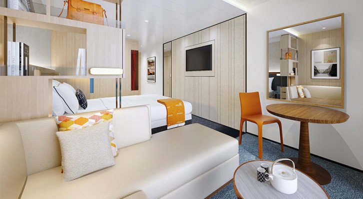
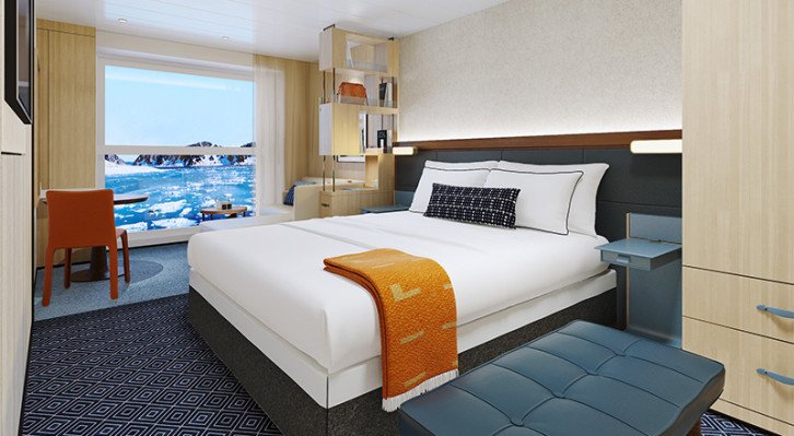
Deluxe Nordic Balcony
Size including Nordic Balcony: 222 sq ft
- 2 PM stateroom access
- Floor-to-ceiling drying closet
- Priority expedition activity reservations (67 days prior to departure)
- One guaranteed priority reservation at each alternative restaurant (60 days prior to departure)
- Priority booking of spa treatments (60 days prior to departure)
- Mini-bar with soft drinks, water & snacks, replenished once daily
- In-suite binoculars, coffee & Marius-weave blanket
FLOORPLANS

Facilities
- Double or Twin Configuration
- Lounge Area
- Shower
- TV
- Safe
- Hair Dryer
- Telephone
Nordic Balcony
Size including Nordic Balcony: 222 sq ft
- 3 PM stateroom access
- Floor-to-ceiling drying closet
- Expedition activity reservations (60 days prior to departure)
- Mini-bar with soft drinks, water & snacks
- In-suite binoculars & Marius-weave blanket
FLOORPLANS

Facilities
- Double or Twin Configuration
- Lounge Area
- Shower
- TV
- Safe
- Telephone
- Desk


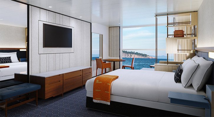
Owner's Suite
- Largest suite on board: 1,223 sq. ft. with a 792 sq. ft. private garden lounge area with badestamp
- All amenities of the Explorer Suite, plus:
- Priority stateroom access
- Floor-to-ceiling drying closet
- Four guaranteed priority reservations at each alternative restaurant (100 days prior to departure)
- First priority expedition activity reservations (107 days prior to departure)
- First priority booking of spa treatments (100 days prior to departure)
- Dinner & guided tour with ship officers (subject to availability)
- Large master bathroom, plus one guest bathroom
- Separate dining area/board room that seats six guests
- Private library, wine & music collections curated by Chairman Torstein Hagen
- And more; ask for details
Facilities
- Double or Twin Configuration
- Lounge Area
- Shower
- TV
- Safe
- Hair Dryer
- Telephone
- Desk
Explorer Suite
Size including Nordic Balcony & private veranda: 580 sq. ft.
- 11 AM stateroom access
- Floor-to-ceiling drying closet
- Priority expedition activity reservations (97 days prior to departure)
- Three guaranteed priority reservations at each alternative restaurant (90 days prior to departure)
- Priority booking of spa treatments (90 days prior to departure)
- Mini-bar with alcoholic beverages, soft drinks, water & snacks, replenished once daily
- In-suite binoculars, coffee & Marius-weave blanket
- Laundry, dry cleaning, pressing & shoe shine services
- Welcome bottle of champagne
- Exclusive access to shared Explorer Suite private garden lounge area
FLOORPLANS
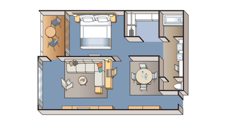
Facilities
- Double or Twin Configuration
- Lounge Area
- Shower
- Free Mini Bar
- TV
- Safe
- Hair Dryer
- Telephone
- Desk
Nordic Junior Suite
Size including Nordic Balcony: 322 sq ft
- 11 AM stateroom access
- Floor-to-ceiling drying closet
- Priority expedition activity reservations (87 days prior to departure)
- Three guaranteed priority reservations at each alternative restaurant (80 days prior to departure)
- Priority booking of spa treatments (80 days prior to departure)
- Mini-bar with alcoholic beverages, soft drinks, water & snacks, replenished once daily
- In-suite binoculars, coffee & Marius-weave blanket
- Laundry, dry cleaning, pressing & shoe shine services
- Bottle of champagne
FLOORPLANS
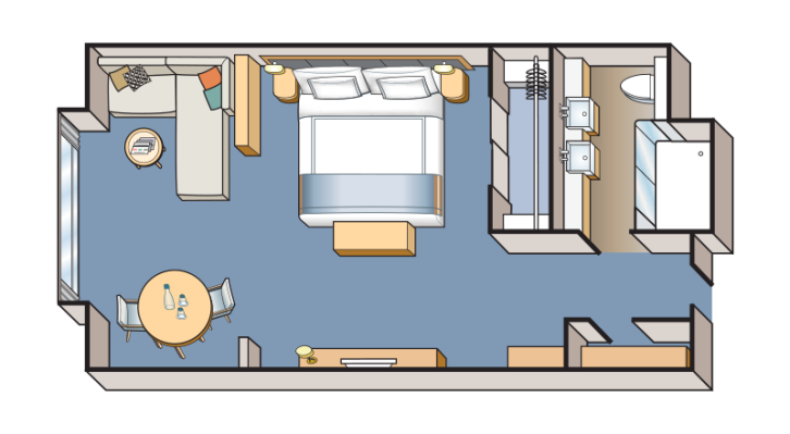
Facilities
- Double or Twin Configuration
- Lounge Area
- Shower
- TV
- Safe
- Hair Dryer
- Telephone
- Desk
Nordic Penthouse
Size including Nordic Balcony: 269 sq ft
- 1 PM stateroom access
- Floor-to-ceiling drying closet
- Priority expedition activity reservations (77 days prior to departure)
- Two guaranteed priority reservations at each alternative restaurant (70 days prior to departure)
- Priority booking of spa treatments (70 days prior to departure)
- Mini-bar with alcoholic beverages, soft drinks, water & snacks, replenished once daily
- In-suite binoculars, coffee & Marius-weave blanket
- Pressing & shoe shine services
- Bottle of champagne
FLOORPLANS
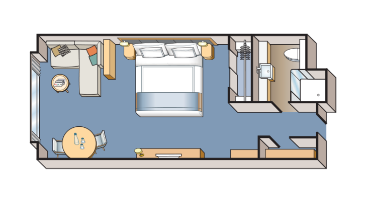
Facilities
- Double or Twin Configuration
- Lounge Area
- Shower
- TV
- Safe
- Telephone
- Desk
-large_thumb.jpg)


-large_thumb.jpg)